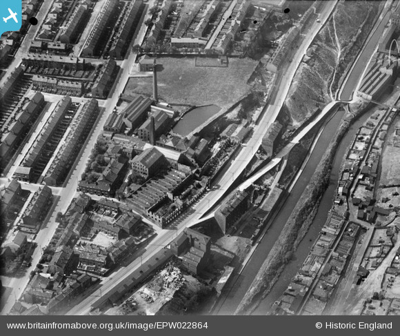
EPW022864 ENGLAND (1928). The Crosland Moor Woollen Mills and the Huddersfield Narrow Canal, Crosland Moor, 1928
© Copyright OpenStreetMap contributors and licensed by the OpenStreetMap Foundation. 2026. Cartography is licensed as CC BY-SA.
Nearby Images (18)
Details
| Title | [EPW022864] The Crosland Moor Woollen Mills and the Huddersfield Narrow Canal, Crosland Moor, 1928 |
| Reference | EPW022864 |
| Date | August-1928 |
| Link | |
| Place name | CROSLAND MOOR |
| Parish | |
| District | |
| Country | ENGLAND |
| Easting / Northing | 413016, 415929 |
| Longitude / Latitude | -1.8031106240195, 53.639481580488 |
| National Grid Reference | SE130159 |
Pins
User Comment Contributions

Photo relating to "Shell of old Fctory?" |

Steve |
Thursday 17th of March 2016 03:16:44 PM |


![[EPW022864] The Crosland Moor Woollen Mills and the Huddersfield Narrow Canal, Crosland Moor, 1928](http://britainfromabove.org.uk/sites/all/libraries/aerofilms-images/public/100x100/EPW/022/EPW022864.jpg)
![[EPW022867] The Crosland Moor Woollen Mills and environs, Crosland Moor, 1928](http://britainfromabove.org.uk/sites/all/libraries/aerofilms-images/public/100x100/EPW/022/EPW022867.jpg)
![[EPW022865] The Crosland Moor Woollen Mills, Crosland Moor, 1928](http://britainfromabove.org.uk/sites/all/libraries/aerofilms-images/public/100x100/EPW/022/EPW022865.jpg)
![[EPW022872] The Crosland Moor Woollen Mills and environs, Crosland Moor, 1928](http://britainfromabove.org.uk/sites/all/libraries/aerofilms-images/public/100x100/EPW/022/EPW022872.jpg)
![[EPW022873] The Crosland Moor Woollen Mills, Crosland Moor, 1928](http://britainfromabove.org.uk/sites/all/libraries/aerofilms-images/public/100x100/EPW/022/EPW022873.jpg)
![[EPW022874] The Crosland Moor Woollen Mills and the Huddersfield Narrow Canal, Crosland Moor, 1928](http://britainfromabove.org.uk/sites/all/libraries/aerofilms-images/public/100x100/EPW/022/EPW022874.jpg)
![[EPW022863] The Crosland Moor Woollen Mills and the Huddersfield Narrow Canal, Crosland Moor, 1928](http://britainfromabove.org.uk/sites/all/libraries/aerofilms-images/public/100x100/EPW/022/EPW022863.jpg)
![[EPW022866] The Crosland Moor Woollen Mills and environs, Crosland Moor, 1928](http://britainfromabove.org.uk/sites/all/libraries/aerofilms-images/public/100x100/EPW/022/EPW022866.jpg)
![[EPW054248] The River Colne valley at Crosland Moor and Milnsbridge, Huddersfield, from the east, 1937](http://britainfromabove.org.uk/sites/all/libraries/aerofilms-images/public/100x100/EPW/054/EPW054248.jpg)
![[EPW054266] The River Colne valley and Crosland Hill, Huddersfield, from the north-east, 1937](http://britainfromabove.org.uk/sites/all/libraries/aerofilms-images/public/100x100/EPW/054/EPW054266.jpg)
![[EAW020077] William Lawton Ltd Mills off Millgate and environs, Paddock, 1948. This image was marked by Aerofilms Ltd for photo editing.](http://britainfromabove.org.uk/sites/all/libraries/aerofilms-images/public/100x100/EAW/020/EAW020077.jpg)
![[EAW020070] William Lawton Ltd Mills off Millgate and environs, Paddock, 1948. This image was marked by Aerofilms Ltd for photo editing.](http://britainfromabove.org.uk/sites/all/libraries/aerofilms-images/public/100x100/EAW/020/EAW020070.jpg)
![[EAW020075] William Lawton Ltd Mills off Millgate and environs, Paddock, 1948. This image was marked by Aerofilms Ltd for photo editing.](http://britainfromabove.org.uk/sites/all/libraries/aerofilms-images/public/100x100/EAW/020/EAW020075.jpg)
![[EAW020074] William Lawton Ltd Mills off Millgate and environs, Paddock, 1948](http://britainfromabove.org.uk/sites/all/libraries/aerofilms-images/public/100x100/EAW/020/EAW020074.jpg)
![[EAW020071] Shires Hill and William Lawton Ltd Mills off Millgate, Paddock, 1948](http://britainfromabove.org.uk/sites/all/libraries/aerofilms-images/public/100x100/EAW/020/EAW020071.jpg)
![[EAW020073] William Lawton Ltd Mills off Millgate and environs, Paddock, 1948](http://britainfromabove.org.uk/sites/all/libraries/aerofilms-images/public/100x100/EAW/020/EAW020073.jpg)
![[EAW020072] William Lawton Ltd Mills off Millgate and environs, Paddock, 1948. This image was marked by Aerofilms Ltd for photo editing.](http://britainfromabove.org.uk/sites/all/libraries/aerofilms-images/public/100x100/EAW/020/EAW020072.jpg)
![[EAW020076] William Lawton Ltd Mills off Millgate and environs, Paddock, 1948](http://britainfromabove.org.uk/sites/all/libraries/aerofilms-images/public/100x100/EAW/020/EAW020076.jpg)