
EPW022734 ENGLAND (1928). East Street and environs, Farnham, 1928

© Copyright OpenStreetMap contributors and licensed by the OpenStreetMap Foundation. 2026. Cartography is licensed as CC BY-SA.
Details
| Title | [EPW022734] East Street and environs, Farnham, 1928 |
| Reference | EPW022734 |
| Date | August-1928 |
| Link | |
| Place name | FARNHAM |
| Parish | FARNHAM |
| District | |
| Country | ENGLAND |
| Easting / Northing | 484356, 147220 |
| Longitude / Latitude | -0.79203814345386, 51.217423937513 |
| National Grid Reference | SU844472 |
Pins

herr68 |
Saturday 27th of September 2025 09:57:16 AM | |
|
Dee |
Sunday 10th of October 2021 08:14:27 PM | |
|
Jim Lawson |
Tuesday 7th of January 2020 02:20:33 PM | |
|
Jim Lawson |
Tuesday 7th of January 2020 02:18:48 PM | |
|
David960 |
Monday 26th of January 2015 07:22:26 PM | |
|
David960 |
Sunday 25th of January 2015 07:09:20 PM | |
|
David960 |
Sunday 25th of January 2015 07:05:54 PM | |
|
David960 |
Sunday 25th of January 2015 07:00:04 PM | |
|
David960 |
Sunday 25th of January 2015 06:35:56 PM | |
|
David960 |
Sunday 25th of January 2015 06:33:31 PM | |
|
David960 |
Sunday 25th of January 2015 06:32:32 PM | |
|
Ian Sargeant |
Saturday 16th of February 2013 01:09:27 PM | |
|
flubber |
Friday 6th of July 2012 12:52:38 AM | |
|
flubber |
Friday 6th of July 2012 12:17:33 AM | |
|
flubber |
Wednesday 4th of July 2012 01:48:53 PM | |
|
Ramblinjohn |
Monday 2nd of July 2012 10:58:30 PM | |
|
Ramblinjohn |
Monday 2nd of July 2012 10:45:16 PM | |
|
Ramblinjohn |
Monday 2nd of July 2012 10:11:20 PM | |
|
Ramblinjohn |
Monday 2nd of July 2012 10:00:53 PM | |
|
Ramblinjohn |
Monday 2nd of July 2012 09:57:22 PM | |
|
Ramblinjohn |
Monday 2nd of July 2012 09:55:35 PM | |
|
Ramblinjohn |
Monday 2nd of July 2012 09:54:21 PM | |
|
Ramblinjohn |
Monday 2nd of July 2012 09:53:31 PM | |
|
Ramblinjohn |
Monday 2nd of July 2012 09:52:42 PM | |
|
Ramblinjohn |
Monday 2nd of July 2012 09:49:46 PM | |
|
Ramblinjohn |
Monday 2nd of July 2012 09:48:54 PM | |
|
Ramblinjohn |
Monday 2nd of July 2012 09:48:06 PM | |
|
EastMarple1 |
Friday 29th of June 2012 04:28:46 PM | |
|
EastMarple1 |
Friday 29th of June 2012 04:26:39 PM | |
The Albion |
Ramblinjohn |
Monday 2nd of July 2012 09:50:42 PM |
|
EastMarple1 |
Friday 29th of June 2012 04:24:33 PM | |
St James's Church (Anglican) |
Ian Sargeant |
Saturday 16th of February 2013 01:06:09 PM |
|
Eton Slaphead |
Friday 29th of June 2012 12:29:53 AM | |
This was The Farnham Motor Company garage |
flubber |
Friday 6th of July 2012 12:19:26 AM |
|
Eton Slaphead |
Friday 29th of June 2012 12:28:12 AM |
User Comment Contributions
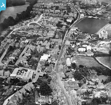
There were lots of pubs along East Street, Farnham. The sites of the Royal Oak, Seven Stars, Swan, White Hart, Eagle, Surrey Arms and Duke of Cambridge can be seen here. |
David960 |
Monday 26th of January 2015 07:24:11 PM |
Is there still any doubt at all on the identification of this? It is definitely East Street heading east towards Hale Road and Guildford Road. Ian notes Farnham Park in the upper left corner. The gas works (no longer there) and St James church (also no longer there) and the Albion pub make it sure. The large open area to the top right was a nursery. The coachworks on the corner of East Street and St Cross is where George Sturt (the author of 'The Wheelwright's Shop' plied his trade. It is now a garage. It is comparable with many photographs that we hold in the Museum of Farnham. |
David Picken |
Monday 20th of October 2014 08:55:40 PM |
Thank you all for your help in identifying this image of FARNHAM - we will update the information for this image when the next upload of data to the website takes place. Best wishes Laura Maddison Britain from Above Cataloguer |

Laura Maddison |
Wednesday 12th of September 2012 09:25:50 AM |
I agree with Ramblinjohn. This is a photo of Farnham, looking Eastward along East Street. |
FarnhamLover |
Thursday 19th of July 2012 05:22:48 PM |
This is Farnham to the NE of image EPW022735. It was taken the same month and was probably taken on the same flight. The white square PH near the top seems to be The Albion, still there although remodelled, at the junction of East St, Hale Road B3007, and Guildford Road A325. The church now seems to be St James' Court apartments alongside East St, with the distinctive small square house just to the NE east still there beyond the modern Farthingfield House. Just to the north of St James, the Stoke Hills road and houses also match the aerial photo. There is a distinctive house on the corner of St Cross Rd and Thorold Rd, which I suggest makes the identification certain. |
Ramblinjohn |
Thursday 19th of July 2012 05:12:27 PM |
Comparing with a Francis Frith 1904 photo, this certainly looks like St James Church. |
FarnhamLover |
Thursday 19th of July 2012 05:12:27 PM |
Dear all, Thanks for your comments so far. This is a tricky one and unfortunately I have been unable to make the Scarborough suggestion work, nothing in the image seems to match the historical mapping for the town. The original Aerofilms Ltd Register entry says "not located - In Berks". Do you have any other ideas where this might be? Katy Whitaker Britain from Above Cataloguer |
Katy Whitaker |
Monday 2nd of July 2012 04:34:52 PM |
there is a house with shingled upper story typical of Kent/Sussex/Essex area.Gas works has one,empty,very early type ,small 'gasometer',ie gas holder.A new plant is being installed. |
Charles |
Sunday 1st of July 2012 04:28:42 PM |