
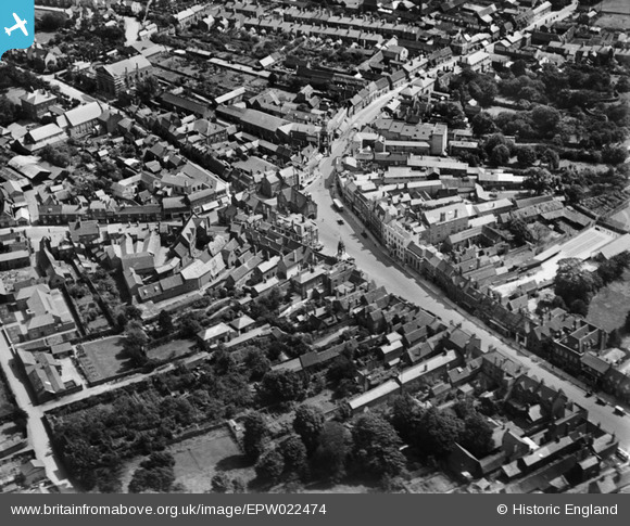
EPW022474 ENGLAND (1928). The Market Square, Leighton Buzzard, 1928
© Copyright OpenStreetMap contributors and licensed by the OpenStreetMap Foundation. 2026. Cartography is licensed as CC BY-SA.
Nearby Images (9)
EPW022474

EPW056940

EPW056934

EPW056941

EPW056937

EPW056938

EPW056936

EPW056939

EPW022454

Details
| Title | [EPW022474] The Market Square, Leighton Buzzard, 1928 |
| Reference | EPW022474 |
| Date | 9-August-1928 |
| Link | |
| Place name | LEIGHTON BUZZARD |
| Parish | LEIGHTON-LINSLADE |
| District | |
| Country | ENGLAND |
| Easting / Northing | 492153, 225072 |
| Longitude / Latitude | -0.65999619610854, 51.916106479897 |
| National Grid Reference | SP922251 |
Pins

Vonderene |
Friday 23rd of August 2013 07:00:00 PM | |
|
Vonderene |
Friday 23rd of August 2013 06:57:57 PM | |
|
Vonderene |
Friday 23rd of August 2013 06:57:10 PM | |
|
Vonderene |
Friday 23rd of August 2013 06:55:07 PM | |
|
Vonderene |
Friday 23rd of August 2013 06:52:10 PM | |
|
Vonderene |
Friday 23rd of August 2013 06:51:04 PM | |
|
Bluid |
Saturday 6th of April 2013 11:41:53 PM | |
|
Bluid |
Saturday 6th of April 2013 11:39:35 PM | |
|
Bluid |
Saturday 6th of April 2013 11:35:07 PM | |
This was the Corn Exchange, built in 1861 the spire was found to be dangerous in 1932 when it was replaced by a flat roof. During WW2 it was used as a social centre for RAF personnel it was demolished completely in 1968 |
Vonderene |
Friday 23rd of August 2013 06:47:44 PM |
|
Bluid |
Saturday 6th of April 2013 11:33:01 PM |