
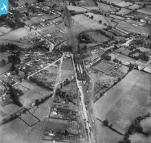
EPW022350 ENGLAND (1928). The railway station and environs, Wickford, 1928

© Copyright OpenStreetMap contributors and licensed by the OpenStreetMap Foundation. 2026. Cartography is licensed as CC BY-SA.
Details
| Title | [EPW022350] The railway station and environs, Wickford, 1928 |
| Reference | EPW022350 |
| Date | August-1928 |
| Link | |
| Place name | WICKFORD |
| Parish | |
| District | |
| Country | ENGLAND |
| Easting / Northing | 574562, 193661 |
| Longitude / Latitude | 0.52157473579627, 51.614200978134 |
| National Grid Reference | TQ746937 |
Pins

Chris Booty |
Sunday 29th of March 2020 10:35:14 PM | |
|
Chris Booty |
Sunday 29th of March 2020 10:32:27 PM | |
|
Chris Booty |
Thursday 21st of February 2019 04:41:49 PM | |
|
Chris Booty |
Thursday 21st of February 2019 04:40:05 PM | |
|
Davel |
Monday 2nd of June 2014 04:07:28 PM | |

hillman34 |
Saturday 6th of July 2013 09:02:52 PM | |
|
hillman34 |
Saturday 6th of July 2013 09:01:24 PM | |
|
Essex Explorer |
Tuesday 23rd of October 2012 02:20:19 AM | |
|
Essex Explorer |
Tuesday 23rd of October 2012 02:19:51 AM | |
|
Essex Explorer |
Tuesday 23rd of October 2012 02:17:25 AM | |
|
Essex Explorer |
Tuesday 23rd of October 2012 02:16:41 AM | |
|
Essex Explorer |
Tuesday 23rd of October 2012 02:15:04 AM |
User Comment Contributions
I've added a few locations to the Wickford Railway Station picture as seen on the 1922 1:2,500 map See http://www.britainfromabove.org.uk/image/epw022350?search=wickford&ref=0 Wickford Railway Station |
Essex Explorer |
Tuesday 23rd of October 2012 02:12:18 PM |