
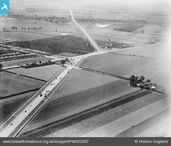
EPW021897 ENGLAND (1928). The Great West Road and the Great South-West Road, Hounslow West, 1928
© Copyright OpenStreetMap contributors and licensed by the OpenStreetMap Foundation. 2026. Cartography is licensed as CC BY-SA.
Nearby Images (2)
EPW021897

EPW043694

Details
| Title | [EPW021897] The Great West Road and the Great South-West Road, Hounslow West, 1928 |
| Reference | EPW021897 |
| Date | July-1928 |
| Link | |
| Place name | HOUNSLOW WEST |
| Parish | |
| District | |
| Country | ENGLAND |
| Easting / Northing | 511786, 176450 |
| Longitude / Latitude | -0.39020863240913, 51.475466327854 |
| National Grid Reference | TQ118765 |
Pins

Martin Devlin |
Wednesday 26th of January 2022 03:37:20 PM | |
 |

Class31 |
Wednesday 2nd of April 2014 09:34:44 AM |
|
longshot |
Thursday 28th of June 2012 07:58:11 PM | |
|
longshot |
Thursday 28th of June 2012 07:56:54 PM | |
|
longshot |
Thursday 28th of June 2012 07:28:26 PM | |
This photo is apparently authenticity described BUT as a local resident with some knowledge of the area there is avery important features that I cannot explain. 1 North of the Travellers, on the other side of the Bath Road,there is clearly the corner of a housing estate - this does not and never has existed. This is Manor Farm and has never been developed. |
Tony Fitzpatrick |
Monday 27th of January 2020 12:20:00 AM |
|
longshot |
Thursday 28th of June 2012 07:26:20 PM | |
|
longshot |
Thursday 28th of June 2012 07:25:09 PM | |
This is the site of Springwell House, just south of where the S-bend was. |
Isleworth1961 |
Tuesday 10th of July 2012 11:31:49 PM |
|
longshot |
Thursday 28th of June 2012 07:23:29 PM | |
|
longshot |
Thursday 28th of June 2012 07:22:17 PM | |
|
longshot |
Thursday 28th of June 2012 07:19:38 PM |
User Comment Contributions
Also running diagonally across the picture is the Bath Road from Hounslow West towards Cranford. Henlys Garage not yet built was later at the apex of the Gt.West Road and the Gt S.West Road. |
Aeronautics |
Wednesday 14th of August 2013 02:22:06 PM |

View looking east with the Great West Road A4 to the left and Bath Road A3006 to the right. Photograph taken yesterday. |
Class31 |
Wednesday 17th of July 2013 09:46:22 AM |
This is a view looking South West above what was the Great West Road (A4)looking towards the junction that is now graced by what is known as Henly's Roundabout. The road coming in from the left is now the A3006 Bath Road from Hounslow - what is now McDonalds is visible half-right - the large structure in the juction between the A4 (to the right) passing North of Heathrow whilst the start of the A30 leads left away into the middle distance. Basildene Road / Francis Road / Vincent Road with houses ICOE to the left. Springwell Road crosses from left centre to centre lower right. No traffic lights (apparently)and Hatton Cross would be in the middle distance with Heathrow Aiport to the right. This is just East and South of Heston aerodrome. |
William Eve, Chartered Surveyors |
Tuesday 21st of August 2012 01:57:47 PM |
Just a note on why its called Henleys roundabout; where the current BP garage is on the roundabout used to be a car showroom selling Fords, and the name of the company was "Henleys" |
scrapemedic |
Thursday 16th of August 2012 05:11:48 PM |
As William Eve correctly states, it's 'Henlys' Roundabout, not 'Henleys', named after the car dealer situated on the roundabout, between the Bath Road and Burns Way. Certainly, as I recall it in it's heyday, it was a BMC dealer, not Ford. Around the country, Henlys were the self-styled "England's leading motor agent". |
Isleworth1961 |
Tuesday 21st of August 2012 01:57:47 PM |
Dear all, That's great; we've reviewed all the suggestions and thanks to your help we can update the catalogue. The revised record will appear here in due course. Hope you have the same success with some of our other mysteries! Katy Britain from Above Cataloguer |
Katy Whitaker |
Monday 2nd of July 2012 11:30:29 AM |
'Aeronautics'....if you check pre-war maps the extended line of the Great West Road passes through the position of the Fairey Hangars on the 'Great West Aerodrome' which was expanded to Heathrow...the pin is roughly where Heathrow Hall was |
longshot |
Saturday 30th of June 2012 09:00:22 PM |
this photo shows the junction of the Great West Road, Bath Road and the South West Road looking in a roughly southerly direction. Also Springwell Road, Heston joins the Gt West Road from the right hand side. Heathrow Aerodrome would have been situated well to the right of the South West Road where the top pin is showing. |
Aeronautics |
Friday 29th of June 2012 05:19:19 PM |
I agree with the other users. My family lived in houses all around this area - all were built in the 30's when the 'Poet's Estate' (Shelley Crescent, Burns Way, Browning Way) was developed along with the other roads. Development was just starting when this was taken - the houses on the A30 are still there. The distinctive three-gable frontage of 'The Travellers Friend' (now McDonald's Bath Road) can be seen centre-right in the 'v' of the A4 and the A30. So I believe this to be the junction looking very roughly south-west. |
Roy |
Tuesday 26th of June 2012 06:36:29 PM |
I think this is the A4, Great West Rd in the foreground and then clockwise, the Bath Rd from Hounslow, the A30 towards Staines and the A4 towards what is now Heathrow. |
APR |
Tuesday 26th of June 2012 02:42:35 PM |
Looks Like the Junction of the A4 and A30 near Heathrow. (A4 towards London centre to bottom left of photo) |
Bill & Veronica |
Monday 25th of June 2012 10:22:46 PM |