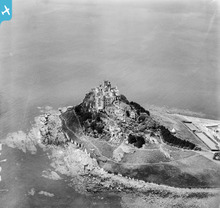
EPW021762 ENGLAND (1928). St Michael's Church and the castle, St Michael's Mount, 1928
© Copyright OpenStreetMap contributors and licensed by the OpenStreetMap Foundation. 2026. Cartography is licensed as CC BY-SA.
Nearby Images (37)
Details
| Title | [EPW021762] St Michael's Church and the castle, St Michael's Mount, 1928 |
| Reference | EPW021762 |
| Date | 24-June-1928 |
| Link | |
| Place name | ST MICHAEL'S MOUNT |
| Parish | ST. MICHAEL'S MOUNT |
| District | |
| Country | ENGLAND |
| Easting / Northing | 151477, 29846 |
| Longitude / Latitude | -5.4768212712918, 50.115953091373 |
| National Grid Reference | SW515298 |
Pins
Be the first to add a comment to this image!
User Comment Contributions

Brian Wilkinson |
Friday 20th of July 2012 09:50:58 AM | |

Alexander Seal |
Sunday 8th of July 2012 04:24:14 PM |


![[EPW021762] St Michael's Church and the castle, St Michael's Mount, 1928](http://britainfromabove.org.uk/sites/all/libraries/aerofilms-images/public/100x100/EPW/021/EPW021762.jpg)
![[EAW005973] St Michael's Mount and the harbour, St Michael's Mount, 1947](http://britainfromabove.org.uk/sites/all/libraries/aerofilms-images/public/100x100/EAW/005/EAW005973.jpg)
![[EAW005975] St Michael's Mount, St Michael's Mount, 1947](http://britainfromabove.org.uk/sites/all/libraries/aerofilms-images/public/100x100/EAW/005/EAW005975.jpg)
![[EAW003639] St Michael's Mount and the harbour, St Michael's Mount, 1947](http://britainfromabove.org.uk/sites/all/libraries/aerofilms-images/public/100x100/EAW/003/EAW003639.jpg)
![[EAW007541] St Michael's Church and the castle, St Michael's Mount, 1947. This image has been produced from a print.](http://britainfromabove.org.uk/sites/all/libraries/aerofilms-images/public/100x100/EAW/007/EAW007541.jpg)
![[EAW005976] St Michael's Mount, St Michael's Mount, 1947](http://britainfromabove.org.uk/sites/all/libraries/aerofilms-images/public/100x100/EAW/005/EAW005976.jpg)
![[EAW005974] St Michael's Mount and the harbour, St Michael's Mount, 1947. This image was marked by Aerofilms Ltd for photo editing.](http://britainfromabove.org.uk/sites/all/libraries/aerofilms-images/public/100x100/EAW/005/EAW005974.jpg)
![[EPW021763] St Michael's Mount, the harbour and the causeway, St Michael's Mount, 1928](http://britainfromabove.org.uk/sites/all/libraries/aerofilms-images/public/100x100/EPW/021/EPW021763.jpg)
![[EAW004867] St Michael's Mount and Gwavas Lake, St Michael's Mount, from the north-east, 1947](http://britainfromabove.org.uk/sites/all/libraries/aerofilms-images/public/100x100/EAW/004/EAW004867.jpg)
![[EAW003640] St Michael's Mount, St Michael's Mount, from the north, 1947](http://britainfromabove.org.uk/sites/all/libraries/aerofilms-images/public/100x100/EAW/003/EAW003640.jpg)
![[EAW007546] St Michael's Church and castle and the harbour, St Michael's Mount, 1947. This image has been produced from a print.](http://britainfromabove.org.uk/sites/all/libraries/aerofilms-images/public/100x100/EAW/007/EAW007546.jpg)
![[EPW021760] St Michael's Mount, the harbour and part of the causeway, St Michael's Mount, 1928](http://britainfromabove.org.uk/sites/all/libraries/aerofilms-images/public/100x100/EPW/021/EPW021760.jpg)
![[EAW005971] St Michael's Mount and the harbour, St Michael's Mount, 1947](http://britainfromabove.org.uk/sites/all/libraries/aerofilms-images/public/100x100/EAW/005/EAW005971.jpg)
![[EAW007544] St Michael's Church and the castle, St Michael's Mount, from the east, 1947](http://britainfromabove.org.uk/sites/all/libraries/aerofilms-images/public/100x100/EAW/007/EAW007544.jpg)
![[EAW004872] St Michael's Mount and the harbour, St Michael's Mount, 1947](http://britainfromabove.org.uk/sites/all/libraries/aerofilms-images/public/100x100/EAW/004/EAW004872.jpg)
![[EAW007547] St Michael's Church and the castle, St Michael's Mount, 1947. This image has been produced from a print.](http://britainfromabove.org.uk/sites/all/libraries/aerofilms-images/public/100x100/EAW/007/EAW007547.jpg)
![[EAW007540] St Michael's Church and the castle, St Michael's Mount, 1947](http://britainfromabove.org.uk/sites/all/libraries/aerofilms-images/public/100x100/EAW/007/EAW007540.jpg)
![[EAW005972] St Michael's Mount and the harbour, St Michael's Mount, 1947](http://britainfromabove.org.uk/sites/all/libraries/aerofilms-images/public/100x100/EAW/005/EAW005972.jpg)
![[EAW004870] St Michael's Mount and Mount's Bay, St Michael's Mount, from the south-east, 1947](http://britainfromabove.org.uk/sites/all/libraries/aerofilms-images/public/100x100/EAW/004/EAW004870.jpg)
![[EPW021764] St Michael's Mount and part of the harbour, St Michael's Mount, 1928](http://britainfromabove.org.uk/sites/all/libraries/aerofilms-images/public/100x100/EPW/021/EPW021764.jpg)
![[EAW007548] St Michael's Church and castle and the harbour, St Michael's Mount, 1947. This image has been produced from a print.](http://britainfromabove.org.uk/sites/all/libraries/aerofilms-images/public/100x100/EAW/007/EAW007548.jpg)
![[EAW007542] St Michael's Church and the castle, St Michael's Mount, from the south-west, 1947](http://britainfromabove.org.uk/sites/all/libraries/aerofilms-images/public/100x100/EAW/007/EAW007542.jpg)
![[EAW003638] St Michael's Mount and the harbour, St Michael's Mount, 1947](http://britainfromabove.org.uk/sites/all/libraries/aerofilms-images/public/100x100/EAW/003/EAW003638.jpg)
![[EAW007543] St Michael's Church and the castle, St Michael's Mount, from the north-west, 1947](http://britainfromabove.org.uk/sites/all/libraries/aerofilms-images/public/100x100/EAW/007/EAW007543.jpg)
![[EPW059660] St Michael's Mount, the harbour and causeway, St Michael's Mount, 1938](http://britainfromabove.org.uk/sites/all/libraries/aerofilms-images/public/100x100/EPW/059/EPW059660.jpg)
![[EAW007545] St Michael's Mount and the harbour, St Michael's Mount, 1947](http://britainfromabove.org.uk/sites/all/libraries/aerofilms-images/public/100x100/EAW/007/EAW007545.jpg)
![[EPW059663] St Michael's Mount, the harbour and causeway, St Michael's Mount, 1938](http://britainfromabove.org.uk/sites/all/libraries/aerofilms-images/public/100x100/EPW/059/EPW059663.jpg)
![[EPW059661] The Church of St Michael, St Michael's Mount, 1938](http://britainfromabove.org.uk/sites/all/libraries/aerofilms-images/public/100x100/EPW/059/EPW059661.jpg)
![[EPW059659] St Michael's Mount, Marazion and the south Cornwall coast, St Michael's Mount, from the south, 1938](http://britainfromabove.org.uk/sites/all/libraries/aerofilms-images/public/100x100/EPW/059/EPW059659.jpg)
![[EPW059664] St Michael's Mount, Marazion and the south Cornwall coast, St Michael's Mount, from the south, 1938](http://britainfromabove.org.uk/sites/all/libraries/aerofilms-images/public/100x100/EPW/059/EPW059664.jpg)
![[EAW015143] St Michael's Mount and the harbour, St Michael's Mount, from the west, 1948](http://britainfromabove.org.uk/sites/all/libraries/aerofilms-images/public/100x100/EAW/015/EAW015143.jpg)
![[EAW015142] St Michael's Mount, the harbour and the causeway, St Michael's Mount, 1948](http://britainfromabove.org.uk/sites/all/libraries/aerofilms-images/public/100x100/EAW/015/EAW015142.jpg)
![[EPW059662] St Michael's Mount, Marazion and the south Cornwall coast, St Michael's Mount, from the south, 1938](http://britainfromabove.org.uk/sites/all/libraries/aerofilms-images/public/100x100/EPW/059/EPW059662.jpg)
![[EAW004869] St Michael's Mount and Marazion, St Michael's Mount, from the south-west, 1947](http://britainfromabove.org.uk/sites/all/libraries/aerofilms-images/public/100x100/EAW/004/EAW004869.jpg)
![[EAW004868] St Michael's Mount and Mount's Bay, St Michael's Mount, from the west, 1947](http://britainfromabove.org.uk/sites/all/libraries/aerofilms-images/public/100x100/EAW/004/EAW004868.jpg)
![[EAW003641] St Michael's Mount and Marazion, St Michael's Mount, from the south-west, 1947](http://britainfromabove.org.uk/sites/all/libraries/aerofilms-images/public/100x100/EAW/003/EAW003641.jpg)
![[EAW004871] St Michael's Mount and Mount's Bay, St Michael's Mount, from the north-west, 1947](http://britainfromabove.org.uk/sites/all/libraries/aerofilms-images/public/100x100/EAW/004/EAW004871.jpg)
