
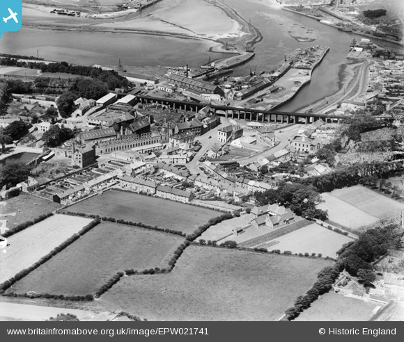
EPW021741 ENGLAND (1928). The railway viaduct and town, Hayle, 1928
© Copyright OpenStreetMap contributors and licensed by the OpenStreetMap Foundation. 2026. Cartography is licensed as CC BY-SA.
Nearby Images (2)
EPW021741

EPW039850

Details
| Title | [EPW021741] The railway viaduct and town, Hayle, 1928 |
| Reference | EPW021741 |
| Date | 24-June-1928 |
| Link | |
| Place name | HAYLE |
| Parish | HAYLE |
| District | |
| Country | ENGLAND |
| Easting / Northing | 155904, 37079 |
| Longitude / Latitude | -5.4196389810019, 50.182731738813 |
| National Grid Reference | SW559371 |
Pins
 |

Peter Turvey |
Monday 24th of November 2014 09:57:18 PM |
|
dave43 |
Sunday 15th of September 2013 08:14:35 PM | |
Was Harvey's new Boiler Shop |
Peter Turvey |
Monday 24th of November 2014 09:55:45 PM |
|
Graham Coad |
Tuesday 20th of August 2013 01:42:25 PM | |
|
Peter Turvey |
Tuesday 31st of July 2012 10:45:26 PM | |
|
dave43 |
Tuesday 3rd of July 2012 10:40:15 PM |
User Comment Contributions

Hayle from the viaduct, July 1967 |

Class31 |
Wednesday 6th of May 2015 06:06:45 PM |
Not Wiltshire |
wayfarer |
Friday 20th of June 2014 05:03:13 PM |
Hayle Railway Viaduct. |

Alexander Seal |
Friday 6th of July 2012 07:07:30 PM |