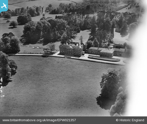
EPW021357 ENGLAND (1928). Shardeloes, Amersham, 1928
© Copyright OpenStreetMap contributors and licensed by the OpenStreetMap Foundation. 2026. Cartography is licensed as CC BY-SA.
Nearby Images (16)
Details
| Title | [EPW021357] Shardeloes, Amersham, 1928 |
| Reference | EPW021357 |
| Date | 27-May-1928 |
| Link | |
| Place name | AMERSHAM |
| Parish | AMERSHAM |
| District | |
| Country | ENGLAND |
| Easting / Northing | 493851, 197846 |
| Longitude / Latitude | -0.64268164620524, 51.671074249267 |
| National Grid Reference | SU939978 |
Pins
Be the first to add a comment to this image!


![[EPW021357] Shardeloes, Amersham, 1928](http://britainfromabove.org.uk/sites/all/libraries/aerofilms-images/public/100x100/EPW/021/EPW021357.jpg)
![[EPW017833] Shardeloes, Shardeloes, 1927](http://britainfromabove.org.uk/sites/all/libraries/aerofilms-images/public/100x100/EPW/017/EPW017833.jpg)
![[EPW044261] Shardeloes, Amersham, 1934](http://britainfromabove.org.uk/sites/all/libraries/aerofilms-images/public/100x100/EPW/044/EPW044261.jpg)
![[EPW021356] Shardeloes, Amersham, 1928](http://britainfromabove.org.uk/sites/all/libraries/aerofilms-images/public/100x100/EPW/021/EPW021356.jpg)
![[EPW021355] Shardeloes, Amersham, 1928](http://britainfromabove.org.uk/sites/all/libraries/aerofilms-images/public/100x100/EPW/021/EPW021355.jpg)
![[EPW044258] Shardeloes, Amersham, 1934](http://britainfromabove.org.uk/sites/all/libraries/aerofilms-images/public/100x100/EPW/044/EPW044258.jpg)
![[EPW044259] Shardeloes House and Park, Amersham, 1934. This image has been produced from a damaged negative.](http://britainfromabove.org.uk/sites/all/libraries/aerofilms-images/public/100x100/EPW/044/EPW044259.jpg)
![[EPW044262] Shardeloes, Amersham, 1934](http://britainfromabove.org.uk/sites/all/libraries/aerofilms-images/public/100x100/EPW/044/EPW044262.jpg)
![[EPW021358] Shardeloes, Amersham, 1928](http://britainfromabove.org.uk/sites/all/libraries/aerofilms-images/public/100x100/EPW/021/EPW021358.jpg)
![[EPW044260] Shardeloes, Amersham, 1934](http://britainfromabove.org.uk/sites/all/libraries/aerofilms-images/public/100x100/EPW/044/EPW044260.jpg)
![[EPW044264] Shardeloes, Amersham, 1934](http://britainfromabove.org.uk/sites/all/libraries/aerofilms-images/public/100x100/EPW/044/EPW044264.jpg)
![[EPW044257] Shardeloes, Amersham, 1934](http://britainfromabove.org.uk/sites/all/libraries/aerofilms-images/public/100x100/EPW/044/EPW044257.jpg)
![[EPW044263] Shardeloes, Amersham, 1934](http://britainfromabove.org.uk/sites/all/libraries/aerofilms-images/public/100x100/EPW/044/EPW044263.jpg)
![[EPW044265] Shardeloes House and Park, Amersham, 1934. This image has been produced from a damaged negative.](http://britainfromabove.org.uk/sites/all/libraries/aerofilms-images/public/100x100/EPW/044/EPW044265.jpg)
![[EPW044886] Shardeloes House and Lower Park, Amersham, 1934](http://britainfromabove.org.uk/sites/all/libraries/aerofilms-images/public/100x100/EPW/044/EPW044886.jpg)
![[EPW044894] Shardeloes Lake and Lower Park, Amersham, 1934](http://britainfromabove.org.uk/sites/all/libraries/aerofilms-images/public/100x100/EPW/044/EPW044894.jpg)