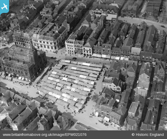
EPW021076 ENGLAND (1928). The Market Place and Market Hall, Chesterfield, 1928
    © Copyright OpenStreetMap contributors and licensed by the OpenStreetMap Foundation. 2025. Cartography is licensed as CC BY-SA.
  
Nearby Images (12)
Details
| Title | [EPW021076] The Market Place and Market Hall, Chesterfield, 1928 | 
| Reference | EPW021076 | 
| Date | May-1928 | 
| Link | |
| Place name | CHESTERFIELD | 
| Parish | |
| District | |
| Country | ENGLAND | 
| Easting / Northing | 438233, 371109 | 
| Longitude / Latitude | -1.4271190080433, 53.235355056585 | 
| National Grid Reference | SK382711 | 
Pins
Be the first to add a comment to this image!
 
             
  ![[EPW021076] The Market Place and Market Hall, Chesterfield, 1928](http://britainfromabove.org.uk/sites/all/libraries/aerofilms-images/public/100x100/EPW/021/EPW021076.jpg) 
  
                                          ![[EPW021079] The Market Place and Market Hall, Chesterfield, 1928](http://britainfromabove.org.uk/sites/all/libraries/aerofilms-images/public/100x100/EPW/021/EPW021079.jpg) 
 ![[EPW057701] Rose Hill, the Market Hall and the town centre, Chesterfield, 1938](http://britainfromabove.org.uk/sites/all/libraries/aerofilms-images/public/100x100/EPW/057/EPW057701.jpg) 
 ![[EPW057697] The Market Hall and Market Place, Chesterfield, 1938](http://britainfromabove.org.uk/sites/all/libraries/aerofilms-images/public/100x100/EPW/057/EPW057697.jpg) 
 ![[EPW021084] The Town Centre, Chesterfield, 1928](http://britainfromabove.org.uk/sites/all/libraries/aerofilms-images/public/100x100/EPW/021/EPW021084.jpg) 
 ![[EPW021083] The Town Centre, Chesterfield, 1928](http://britainfromabove.org.uk/sites/all/libraries/aerofilms-images/public/100x100/EPW/021/EPW021083.jpg) 
 ![[EPW057698] Burlington Street and environs, Chesterfield, 1938](http://britainfromabove.org.uk/sites/all/libraries/aerofilms-images/public/100x100/EPW/057/EPW057698.jpg) 
 ![[EPW021078] New Square, Chesterfield, 1928](http://britainfromabove.org.uk/sites/all/libraries/aerofilms-images/public/100x100/EPW/021/EPW021078.jpg) 
 ![[EPW057700] St Mary and All Saints Church, Knifesmith Gate, Burlington Street and environs, Chesterfield, 1938](http://britainfromabove.org.uk/sites/all/libraries/aerofilms-images/public/100x100/EPW/057/EPW057700.jpg) 
 ![[EPW021077] St Mary and All Saints' Church and The Market Hall, Chesterfield, 1928](http://britainfromabove.org.uk/sites/all/libraries/aerofilms-images/public/100x100/EPW/021/EPW021077.jpg) 
 ![[EPW057699] Lordsmill Street, Markham Road and the town centre, Chesterfield, 1938](http://britainfromabove.org.uk/sites/all/libraries/aerofilms-images/public/100x100/EPW/057/EPW057699.jpg) 
 ![[EPW021081] The town centre, Chesterfield, 1928](http://britainfromabove.org.uk/sites/all/libraries/aerofilms-images/public/100x100/EPW/021/EPW021081.jpg)