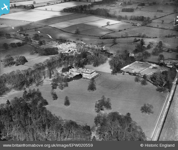
EPW020559 ENGLAND (1928). Newby Wiske Hall, Newby Wiske, 1928
© Copyright OpenStreetMap contributors and licensed by the OpenStreetMap Foundation. 2025. Cartography is licensed as CC BY-SA.
Nearby Images (10)
Details
| Title | [EPW020559] Newby Wiske Hall, Newby Wiske, 1928 |
| Reference | EPW020559 |
| Date | March-1928 |
| Link | |
| Place name | NEWBY WISKE |
| Parish | NEWBY WISKE |
| District | |
| Country | ENGLAND |
| Easting / Northing | 436637, 487545 |
| Longitude / Latitude | -1.4372109481364, 54.282069967001 |
| National Grid Reference | SE366875 |
Pins
Be the first to add a comment to this image!


![[EPW020559] Newby Wiske Hall, Newby Wiske, 1928](http://britainfromabove.org.uk/sites/all/libraries/aerofilms-images/public/100x100/EPW/020/EPW020559.jpg)
![[EPW019847] Newby Wiske Hall, Newby Wiske, 1927](http://britainfromabove.org.uk/sites/all/libraries/aerofilms-images/public/100x100/EPW/019/EPW019847.jpg)
![[EPW020558] Newby Wiske Hall, Newby Wiske, 1928](http://britainfromabove.org.uk/sites/all/libraries/aerofilms-images/public/100x100/EPW/020/EPW020558.jpg)
![[EPW019849] Newby Wiske Hall, Newby Wiske, 1927](http://britainfromabove.org.uk/sites/all/libraries/aerofilms-images/public/100x100/EPW/019/EPW019849.jpg)
![[EPW019852] Newby Wiske Hall, Newby Wiske, 1927](http://britainfromabove.org.uk/sites/all/libraries/aerofilms-images/public/100x100/EPW/019/EPW019852.jpg)
![[EPW019851] Newby Wiske Hall, Newby Wiske, 1927](http://britainfromabove.org.uk/sites/all/libraries/aerofilms-images/public/100x100/EPW/019/EPW019851.jpg)
![[EPW020563] Newby Wiske Hall, Newby Wiske, from the north-east, 1928](http://britainfromabove.org.uk/sites/all/libraries/aerofilms-images/public/100x100/EPW/020/EPW020563.jpg)
![[EPW020561] Newby Wiske Hall, Newby Wiske, from the south-east, 1928](http://britainfromabove.org.uk/sites/all/libraries/aerofilms-images/public/100x100/EPW/020/EPW020561.jpg)
![[EPW020560] Newby Wiske Hall, Newby Wiske, from the south-east, 1928](http://britainfromabove.org.uk/sites/all/libraries/aerofilms-images/public/100x100/EPW/020/EPW020560.jpg)
![[EPW020562] Newby Wiske Hall, Newby Wiske, from the south-west, 1928](http://britainfromabove.org.uk/sites/all/libraries/aerofilms-images/public/100x100/EPW/020/EPW020562.jpg)