
EPW020458 ENGLAND (1928). The Colour Works, Spondon, 1928
© Copyright OpenStreetMap contributors and licensed by the OpenStreetMap Foundation. 2026. Cartography is licensed as CC BY-SA.
Nearby Images (9)
EPW020458

EPW020858

EPW007494

EPW007491

EPW007489

EPW007492

EPW007495

EPW007490

EPW007496

Details
| Title | [EPW020458] The Colour Works, Spondon, 1928 |
| Reference | EPW020458 |
| Date | 16-March-1928 |
| Link | |
| Place name | SPONDON |
| Parish | |
| District | |
| Country | ENGLAND |
| Easting / Northing | 439175, 335375 |
| Longitude / Latitude | -1.4173575593211, 52.914050747333 |
| National Grid Reference | SK392354 |
Pins

Peter Kazmierczak |
Monday 23rd of September 2013 07:52:43 PM | |
|
Peter Kazmierczak |
Thursday 12th of September 2013 09:15:53 PM | |

MB |
Thursday 30th of August 2012 08:21:13 AM | |
|
BigglesH |
Monday 2nd of July 2012 04:05:33 AM | |
|
BigglesH |
Monday 2nd of July 2012 03:59:47 AM | |
|
BigglesH |
Monday 2nd of July 2012 03:56:27 AM | |
|
BigglesH |
Monday 2nd of July 2012 03:55:10 AM | |
|
BigglesH |
Monday 2nd of July 2012 03:53:15 AM |
User Comment Contributions
I'd suggest that this image does not arise from flight AFL3155. Almost every detail of this scene has changed considerably in the last 80+ years - however the double-roofed houses(?) with their chimney stacks immediately beyond the level crossing in the foreground are still recognisable on modern aerial images |
Calchfaen |
Wednesday 31st of July 2013 10:12:35 PM |
Calchfaen, I'm afraid that you have mistaken the houses mentioned in the foreground with those on Holme Lane further up the railway line, opposite the main office of the former British Celanese/Courtaulds site. Triggy. |
Triggy |
Wednesday 31st of July 2013 10:12:35 PM |
You can get to this image by typing "Nottingham" in the search box - not even in the same County! |
old_geezer |
Thursday 13th of December 2012 06:47:59 PM |
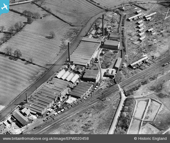
This is the works near Spondon, east of Derby within OS grid square SK3935 The railway was (at one time) the London, Midland and Scottish Railway. The Derby Canal has now gone. The A6005 is seen in the extreme top corner of the shot. |
Calchfaen |
Wednesday 24th of October 2012 09:21:59 AM |
Hi Calchfaen, That’s great; we’ve reviewed your comment and thanks to your help we can update the catalogue. The revised record will appear here in due course. The detailed information on the image is great - the original Aerofilms Ltd Register entry says "Greater London Trust Mud Flats at Calshot"! Yours, Katy Britain from Above Cataloguing Team Leader |
Katy Whitaker |
Wednesday 24th of October 2012 09:21:59 AM |
Friargate's comments are fully supported. It is fascinating to see the lants still evident in the fields from earlier arrangements for cultivation. I remember similar characteristics in the field behind our house in nearby Borrowash in the 1950s, now sadly long gone. Has anyone located a photo of nearby Spondon Power Station? |
JoSpr |
Saturday 22nd of September 2012 01:25:11 AM |
This view is looking north-east at Spondon, just to the east of Derby. The railway line is the London Midland & Scottish Railway route from Derby to Nottingham, Leicester and London St Pancras; Spondon Junction signal box can just be seen in the bottom left-hand corner. The road running from top to bottom with a level crossing over the railway is Megaloughton Lane, while the large factory complex is the colour works of Messrs Leech, Neal & Company, some buildings of which survive today as part of a scrapyard. The canal is the Derby-Sandiacre arm of the Derby Canal on which traffic ceased in 1945 but which was not formally abandoned until 1964. The rows of cottages to the right of Megaloughton Lane look like 'navvy dwellings' and I wonder if they housed originally construction workers engaged on building the nearby British Cellulose & Chemical Manufacturing Company's factory (later British Celanese) just off-camera to the right? Their arrangement suggests there were once more of them - later all were demolished and the site used as a tip. Ridge and furrow is prominent in the fields beyond the canal - in the late 1970s this area was used to construct the Derby-Spondon section of the A52 (more recently named Brian Clough Way) and its associated junctions with the Derby Ring Road (A5111). This supplanted the road (Derby Road) at top left as the main route. Bottom right are settling ponds associated with Derby's main sewage works. |
Friargate |
Wednesday 11th of July 2012 09:26:01 PM |
Spot on Friargate. The 'Navvy' houses were known as the Wimpey estate, more were built as the British Celanese factory got bigger, the 'Wimpey' houses being for the construction workers at the Cel. My dad helped build them and also lived in one for a short while. In the 50's I can remember a school friend living in one. Albert Looms is the scrap yard now and ASDA is north of that where the fields are. Dave Trigg. |
Triggy |
Wednesday 11th of July 2012 09:26:01 PM |
Comparison with view EPW007496 taken six years earlier does indeed confirm that there were more of the 'navvy dwellings' than survive here (see my previous comments). |
Friargate |
Tuesday 3rd of July 2012 09:55:08 PM |
Shadows from chimneys indicate photo taken from the West/ North-West. Convergence of Canal and Railway (bridge to left) should help identify. |
BigglesH |
Monday 2nd of July 2012 04:12:09 AM |