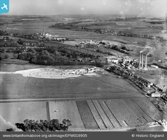
EPW019905 ENGLAND (1927). Holborough Quarry and environs, Holborough, from the south-west, 1927
© Copyright OpenStreetMap contributors and licensed by the OpenStreetMap Foundation. 2026. Cartography is licensed as CC BY-SA.
Details
| Title | [EPW019905] Holborough Quarry and environs, Holborough, from the south-west, 1927 |
| Reference | EPW019905 |
| Date | October-1927 |
| Link | |
| Place name | HOLBOROUGH |
| Parish | SNODLAND |
| District | |
| Country | ENGLAND |
| Easting / Northing | 570190, 162280 |
| Longitude / Latitude | 0.44336591644982, 51.333603146325 |
| National Grid Reference | TQ702623 |
Pins

Dylan Moore |
Thursday 10th of January 2019 04:31:34 PM | |

Dylan Moore |
Tuesday 15th of July 2014 12:54:05 AM | |

Dylan Moore |
Tuesday 15th of July 2014 12:27:55 AM | |

Dylan Moore |
Saturday 22nd of June 2013 08:50:41 PM | |

Dylan Moore |
Saturday 22nd of June 2013 08:49:57 PM | |

Dylan Moore |
Saturday 22nd of June 2013 08:49:18 PM | |

Dylan Moore |
Saturday 22nd of June 2013 08:47:16 PM | |

Dylan Moore |
Tuesday 16th of October 2012 11:33:22 AM | |

Dylan Moore |
Tuesday 16th of October 2012 11:32:47 AM | |

Dylan Moore |
Tuesday 16th of October 2012 11:32:10 AM |
User Comment Contributions
For details, history and many links, see [[http://www.cementkilns.co.uk/cement_kiln_holborough.html]], [[http://www.cementkilns.co.uk/cement_kiln_lees.html]] and [[http://www.cementkilns.co.uk/cement_kiln_halling_manor.html]]. |

Dylan Moore |
Thursday 18th of October 2012 09:26:00 PM |

Dylan Moore |
Tuesday 16th of October 2012 07:09:02 PM |


![[EPW019905] Holborough Quarry and environs, Holborough, from the south-west, 1927](http://britainfromabove.org.uk/sites/all/libraries/aerofilms-images/public/100x100/EPW/019/EPW019905.jpg)
![[EPW019910] Holborough Quarry and Cement Works, Holborough from the south-west, 1927](http://britainfromabove.org.uk/sites/all/libraries/aerofilms-images/public/100x100/EPW/019/EPW019910.jpg)
![[EPW019909] Holborough Quarry and Cement Works, Holborough, 1927](http://britainfromabove.org.uk/sites/all/libraries/aerofilms-images/public/100x100/EPW/019/EPW019909.jpg)
![[EPW019902] Holborough Cement Works and Quarry, Holborough, 1927](http://britainfromabove.org.uk/sites/all/libraries/aerofilms-images/public/100x100/EPW/019/EPW019902.jpg)
