
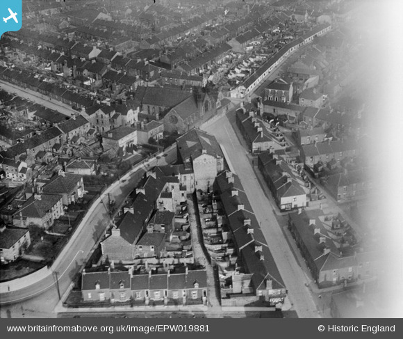
EPW019881 ENGLAND (1927). St Bede's Church and environs, Jarrow, 1927
© Copyright OpenStreetMap contributors and licensed by the OpenStreetMap Foundation. 2026. Cartography is licensed as CC BY-SA.
Nearby Images (2)
EPW019881

EPW019883

Details
| Title | [EPW019881] St Bede's Church and environs, Jarrow, 1927 |
| Reference | EPW019881 |
| Date | October-1927 |
| Link | |
| Place name | JARROW |
| Parish | |
| District | |
| Country | ENGLAND |
| Easting / Northing | 432901, 565054 |
| Longitude / Latitude | -1.4858862766114, 54.978929433405 |
| National Grid Reference | NZ329651 |
Pins

plainjayne |
Tuesday 28th of April 2015 11:08:30 PM | |
|
Vin Mullen |
Saturday 7th of June 2014 07:17:28 PM | |
|
Vin Mullen |
Saturday 7th of June 2014 07:16:20 PM | |
|
Vin Mullen |
Saturday 7th of June 2014 07:15:12 PM | |
|
Vin Mullen |
Saturday 7th of June 2014 07:14:27 PM | |
|
Vin Mullen |
Saturday 7th of June 2014 07:13:44 PM | |
|
Vin Mullen |
Saturday 7th of June 2014 07:13:10 PM | |
|
Vin Mullen |
Saturday 7th of June 2014 07:12:33 PM | |
|
Vin Mullen |
Saturday 7th of June 2014 07:11:26 PM | |
|
Vin Mullen |
Saturday 7th of June 2014 07:09:30 PM | |
|
N Dunn |
Thursday 12th of September 2013 09:49:10 AM | |
 |
N Dunn |
Thursday 12th of September 2013 09:48:34 AM |
|
Vin Mullen |
Thursday 8th of August 2013 02:26:38 AM | |
|
Vin Mullen |
Thursday 8th of August 2013 02:24:44 AM | |
|
Vin Mullen |
Thursday 8th of August 2013 02:13:30 AM | |
|
Vin Mullen |
Thursday 8th of August 2013 02:08:22 AM | |
|
Vin Mullen |
Thursday 8th of August 2013 02:06:42 AM | |
|
Vin Mullen |
Thursday 8th of August 2013 01:57:35 AM |