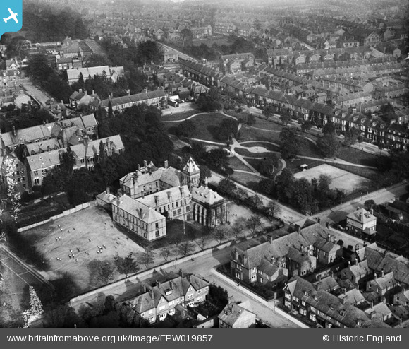
EPW019857 ENGLAND (1927). The Grammar School and Stanhope Green, Darlington, 1927
© Copyright OpenStreetMap contributors and licensed by the OpenStreetMap Foundation. 2025. Cartography is licensed as CC BY-SA.
Details
| Title | [EPW019857] The Grammar School and Stanhope Green, Darlington, 1927 |
| Reference | EPW019857 |
| Date | October-1927 |
| Link | |
| Place name | DARLINGTON |
| Parish | |
| District | |
| Country | ENGLAND |
| Easting / Northing | 428289, 514629 |
| Longitude / Latitude | -1.5628606511028, 54.526026969935 |
| National Grid Reference | NZ283146 |
Pins
 Chells809 |
Wednesday 10th of April 2013 08:40:37 PM | |
 Class31 |
Monday 9th of July 2012 10:15:50 AM | |
 Class31 |
Monday 9th of July 2012 10:14:31 AM | |
 Class31 |
Monday 9th of July 2012 10:11:47 AM | |
 Class31 |
Monday 9th of July 2012 10:09:09 AM | |
 Class31 |
Monday 9th of July 2012 10:08:25 AM |


![[EPW019857] The Grammar School and Stanhope Green, Darlington, 1927](http://britainfromabove.org.uk/sites/all/libraries/aerofilms-images/public/100x100/EPW/019/EPW019857.jpg)
![[EPW029508] Stanhope Green and Darlington College of Education, Darlington, 1929](http://britainfromabove.org.uk/sites/all/libraries/aerofilms-images/public/100x100/EPW/029/EPW029508.jpg)
![[EPW029507] Darlington College of Education and Darlington Grammar School, Darlington, 1929](http://britainfromabove.org.uk/sites/all/libraries/aerofilms-images/public/100x100/EPW/029/EPW029507.jpg)