
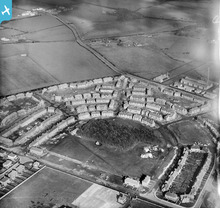
EPW019811 ENGLAND (1927). New housing at Heaton High Pit, Heaton, 1927

© Copyright OpenStreetMap contributors and licensed by the OpenStreetMap Foundation. 2026. Cartography is licensed as CC BY-SA.
Nearby Images (2)
EPW019811

EPW060135

Details
| Title | [EPW019811] New housing at Heaton High Pit, Heaton, 1927 |
| Reference | EPW019811 |
| Date | October-1927 |
| Link | |
| Place name | HEATON |
| Parish | |
| District | |
| Country | ENGLAND |
| Easting / Northing | 426735, 566992 |
| Longitude / Latitude | -1.582052588819, 54.996715286446 |
| National Grid Reference | NZ267670 |
Pins

plucoupler |
Friday 12th of September 2014 04:20:13 AM | |
|
plucoupler |
Friday 12th of September 2014 04:17:35 AM | |
|
plucoupler |
Friday 12th of September 2014 04:14:26 AM |
User Comment Contributions
High Heaton estate |
Oldheaton |
Sunday 21st of July 2013 12:41:05 AM |
High Heaton estate and open fields beyond. |
Oldheaton |
Sunday 21st of July 2013 12:29:05 AM |
In the foreground is Heaton Secondary School still being built, to be opened by King George V on 10th October 1928, the same day that he opened the Tyne Bridge. The caretakers house in the bottom right hand corner was destroyed by a German bomb during WW2. The school was divided into two carbon copy halves, split down the centre of the playing fields by a brick wall. This picture shows the girls school portion, later known as Heaton High School. The boys half became Heaton Grammar School. THey became co-educational and comprehensive in September 1967 and later merged with Manor Park School to become Heaton Manor. The school buildings just being erected at the bottom of this shot were hit by two further bombs, but all was rebuilt. However, the 'old' school was demolished and another purpose built new school was opened in 2003. |
NE2 3PN |
Saturday 30th of June 2012 03:23:12 PM |