
EPW019805 ENGLAND (1927). Heaton Gramar School for Boys and Heaton High School for Girls, Heaton, 1927

© Copyright OpenStreetMap contributors and licensed by the OpenStreetMap Foundation. 2026. Cartography is licensed as CC BY-SA.
Details
| Title | [EPW019805] Heaton Gramar School for Boys and Heaton High School for Girls, Heaton, 1927 |
| Reference | EPW019805 |
| Date | October-1927 |
| Link | |
| Place name | HEATON |
| Parish | |
| District | |
| Country | ENGLAND |
| Easting / Northing | 426399, 566667 |
| Longitude / Latitude | -1.5873350866753, 54.993812443309 |
| National Grid Reference | NZ264667 |
Pins
Be the first to add a comment to this image!
User Comment Contributions
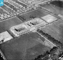
Looking North Shows Southlands towards top and Newton Road to the right. |

Oldheaton |
Sunday 21st of July 2013 12:26:04 AM |