
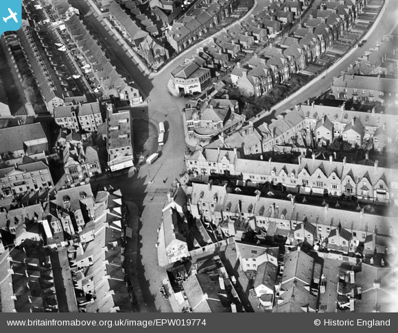
EPW019774 ENGLAND (1927). Oxford Street, Whitley Bay, 1927
© Copyright OpenStreetMap contributors and licensed by the OpenStreetMap Foundation. 2026. Cartography is licensed as CC BY-SA.
Nearby Images (5)
EPW019774

EPW019775

EPW019766

EPW019767

EPW019771

Details
| Title | [EPW019774] Oxford Street, Whitley Bay, 1927 |
| Reference | EPW019774 |
| Date | 18-October-1927 |
| Link | |
| Place name | WHITLEY BAY |
| Parish | |
| District | |
| Country | ENGLAND |
| Easting / Northing | 435626, 572119 |
| Longitude / Latitude | -1.4424272196352, 55.042233611277 |
| National Grid Reference | NZ356721 |
Pins

tony |
Wednesday 11th of February 2015 08:56:11 PM | |
|
tony |
Thursday 20th of June 2013 03:59:51 PM | |
|
Eric Hollerton |
Friday 24th of August 2012 03:44:01 PM | |
|
Eric Hollerton |
Friday 24th of August 2012 03:19:55 PM | |
|
Eric Hollerton |
Friday 24th of August 2012 02:36:44 PM |
User Comment Contributions
Whitley Road runs roughly east and west across the photograph, just below the centre line. Very broadly speaking, the old village of Whitley lay to the left. The area to the right was largely open land on the Ordnance Survey of 1895. Three buses are parked next to the new Woolworth's store. To the north the road divides at the Primitive Methodist Church. On the left is Oxford Street, the the right, North Parade. South Parade curves away from the middle, towards to top right of the picture. The view includes the Victoria Hotel, the fire station, and the old Council Offices. |
Eric Hollerton |
Friday 24th of August 2012 03:10:46 PM |