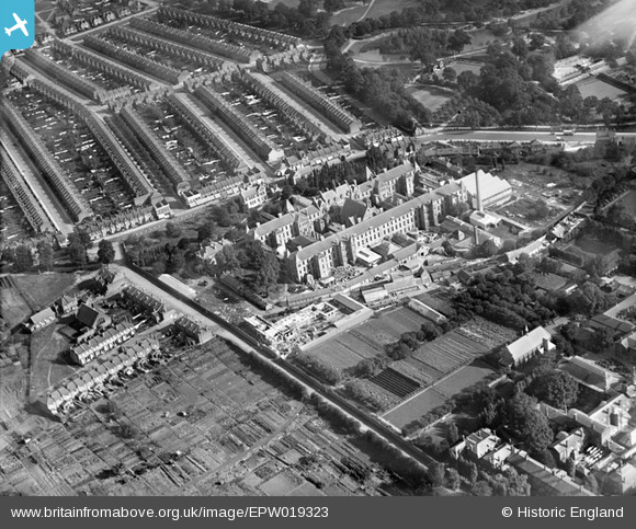
EPW019323 ENGLAND (1927). The former Strand Union Workhouse, Edmonton, 1927
© Copyright OpenStreetMap contributors and licensed by the OpenStreetMap Foundation. 2024. Cartography is licensed as CC BY-SA.
Nearby Images (18)
Details
| Title | [EPW019323] The former Strand Union Workhouse, Edmonton, 1927 |
| Reference | EPW019323 |
| Date | 23-September-1927 |
| Link | |
| Place name | EDMONTON |
| Parish | |
| District | |
| Country | ENGLAND |
| Easting / Northing | 533366, 192429 |
| Longitude / Latitude | -0.073558491181102, 51.614399315712 |
| National Grid Reference | TQ334924 |
Pins
 bugbear |
Friday 16th of August 2013 02:25:42 PM | |
 bugbear |
Friday 16th of August 2013 02:25:17 PM | |
 bugbear |
Friday 16th of August 2013 02:24:59 PM | |
 bugbear |
Friday 16th of August 2013 02:24:41 PM | |
 bugbear |
Friday 16th of August 2013 02:24:17 PM | |
 bugbear |
Friday 16th of August 2013 02:23:48 PM | |
 bugbear |
Friday 16th of August 2013 02:23:17 PM | |
I think it's Bull Lane, actually - or was in 1936. MW |
 martinwinlow |
Saturday 19th of July 2014 01:17:52 PM |


![[EPW019323] The former Strand Union Workhouse, Edmonton, 1927](http://britainfromabove.org.uk/sites/all/libraries/aerofilms-images/public/100x100/EPW/019/EPW019323.jpg)
![[EPW019331] The former Strand Union Workhouse and environs, Edmonton, 1927](http://britainfromabove.org.uk/sites/all/libraries/aerofilms-images/public/100x100/EPW/019/EPW019331.jpg)
![[EPW019328] The former Strand Union Workhouse, Edmonton, 1927](http://britainfromabove.org.uk/sites/all/libraries/aerofilms-images/public/100x100/EPW/019/EPW019328.jpg)
![[EPW019325] The former Strand Union Workhouse and environs, Edmonton, 1927](http://britainfromabove.org.uk/sites/all/libraries/aerofilms-images/public/100x100/EPW/019/EPW019325.jpg)
![[EPW019319] The former Strand Union Workhouse, Edmonton, 1927. This image was marked by Aerofilms for photo editing.](http://britainfromabove.org.uk/sites/all/libraries/aerofilms-images/public/100x100/EPW/019/EPW019319.jpg)
![[EPW019322] The former Strand Union Workhouse, Edmonton, 1927](http://britainfromabove.org.uk/sites/all/libraries/aerofilms-images/public/100x100/EPW/019/EPW019322.jpg)
![[EPW019329] The former Strand Union Workhouse, Edmonton, 1927](http://britainfromabove.org.uk/sites/all/libraries/aerofilms-images/public/100x100/EPW/019/EPW019329.jpg)
![[EPW019332] The former Strand Union Workhouse, Edmonton, 1927](http://britainfromabove.org.uk/sites/all/libraries/aerofilms-images/public/100x100/EPW/019/EPW019332.jpg)
![[EPW019320] The former Strand Union Workhouse, Edmonton, 1927](http://britainfromabove.org.uk/sites/all/libraries/aerofilms-images/public/100x100/EPW/019/EPW019320.jpg)
![[EPW019321] The former Strand Union Workhouse, Edmonton, 1927](http://britainfromabove.org.uk/sites/all/libraries/aerofilms-images/public/100x100/EPW/019/EPW019321.jpg)
![[EPW019318] The former Strand Union Workhouse, Edmonton, 1927](http://britainfromabove.org.uk/sites/all/libraries/aerofilms-images/public/100x100/EPW/019/EPW019318.jpg)
![[EPW019334] The former Strand Union Workhouse, Edmonton, 1927](http://britainfromabove.org.uk/sites/all/libraries/aerofilms-images/public/100x100/EPW/019/EPW019334.jpg)
![[EPW019324] The former Strand Union Workhouse and environs, Edmonton, 1927](http://britainfromabove.org.uk/sites/all/libraries/aerofilms-images/public/100x100/EPW/019/EPW019324.jpg)
![[EPW019317] The former Strand Union Workhouse, Edmonton, 1927](http://britainfromabove.org.uk/sites/all/libraries/aerofilms-images/public/100x100/EPW/019/EPW019317.jpg)
![[EPW019327] The former Strand Union Workhouse, Edmonton, 1927](http://britainfromabove.org.uk/sites/all/libraries/aerofilms-images/public/100x100/EPW/019/EPW019327.jpg)
![[EPW019330] The former Strand Union Workhouse, Edmonton, 1927](http://britainfromabove.org.uk/sites/all/libraries/aerofilms-images/public/100x100/EPW/019/EPW019330.jpg)
![[EPW019326] The former Strand Union Workhouse, Edmonton, 1927](http://britainfromabove.org.uk/sites/all/libraries/aerofilms-images/public/100x100/EPW/019/EPW019326.jpg)
![[EPW019333] The former Strand Union Workhouse, Edmonton, 1927](http://britainfromabove.org.uk/sites/all/libraries/aerofilms-images/public/100x100/EPW/019/EPW019333.jpg)