
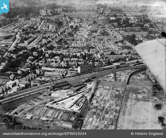
EPW019244 ENGLAND (1927). The town centre, St Albans, from the east, 1927
© Copyright OpenStreetMap contributors and licensed by the OpenStreetMap Foundation. 2026. Cartography is licensed as CC BY-SA.
Nearby Images (2)
EPW019244

EPW019245

Details
| Title | [EPW019244] The town centre, St Albans, from the east, 1927 |
| Reference | EPW019244 |
| Date | August-1927 |
| Link | |
| Place name | ST ALBANS |
| Parish | |
| District | |
| Country | ENGLAND |
| Easting / Northing | 515496, 206816 |
| Longitude / Latitude | -0.32679849354926, 51.747666378639 |
| National Grid Reference | TL155068 |
Pins

John W |
Tuesday 5th of January 2021 08:59:02 PM | |
|
John W |
Saturday 11th of July 2020 06:12:17 PM | |
|
John W |
Friday 29th of April 2016 08:59:40 PM | |
|
John W |
Friday 29th of April 2016 08:57:35 PM | |
|
John W |
Friday 29th of April 2016 08:56:48 PM | |
|
Philip |
Saturday 29th of November 2014 09:04:48 PM | |
|
Philip |
Saturday 29th of November 2014 09:02:47 PM | |
This is St Albans South Signal Box, built in 1892 when the Midland Railway was preparing to add two more lines from St Albans southwards to London. Grade II listed February 1979. Abandoned by British Railways early 1980. Leased to a Preservation Trust in 2006, restored, and then opened to the public late 2008. See www.sigbox.co.uk for information on regular Open Afternoons. |
John W |
Friday 29th of April 2016 08:36:06 PM |
|
MB |
Thursday 11th of October 2012 08:15:54 AM | |
|
MB |
Thursday 11th of October 2012 08:14:19 AM | |
|
MB |
Thursday 11th of October 2012 08:12:25 AM | |
|
MB |
Thursday 11th of October 2012 08:11:36 AM | |
Happy days! |
Philip |
Saturday 29th of November 2014 07:53:57 PM |
|
MB |
Thursday 11th of October 2012 08:11:02 AM | |
Roof vents suggest you're right. |
Philip |
Saturday 29th of November 2014 07:52:26 PM |
I can confirm that was St Albans Engine shed, of two roads, and housed mainly tank engines to run the local passenger services into St Pancras and Moorgate. Closed 1960 after Diesel Multiple Units took over the local passenger services, and demolished 1965. A large multi-storey carpark and flats now cover the site. |
John W |
Friday 29th of April 2016 08:41:58 PM |
|
MB |
Thursday 11th of October 2012 08:10:35 AM | |
This was indeed a coaling plant, although it was all done by manpower and little machinery. Note to the left of the building the long stacks of coal - the railway would buy coal cheaply in the Summer and to ensure they had stocks in the Winter if deliveries were disrupted by weather. |
John W |
Friday 29th of April 2016 08:54:05 PM |
|
MB |
Thursday 11th of October 2012 08:09:55 AM | |
|
MB |
Thursday 11th of October 2012 08:09:13 AM | |
This was actually built by the St Alban City 'Fathers' in the 1860s, and only became part of the HM Prison Service at a later (unknown) date. It was taken over by the Military in WW1; they abandoned it soon after. The City council reacquired it and was used as a Council yard for many years. The area was cleared and new offices built on the area in recent years. The only remaining parts of the prison are the walls and gatehouse facing onto Victoria Street/Grimston Road. The gatehouse was used in 'Porridge'. It had been said that he building of the prison prior to the Midland Railway line led to the latter being deviated to put the station on the city side of the prison! But this is incorrect - the original railway line would have run further to the east and the City station station would have been built on London Road even further away from the city centre than the present station. The City Fathers gave surplus land next to the prison to the Midland Railway to persuade them to resite the station and railway to their present position. |
John W |
Friday 29th of April 2016 08:51:10 PM |
|
MB |
Thursday 11th of October 2012 08:07:11 AM |