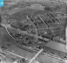
EPW019173 ENGLAND (1927). The London and North Western Railway Goods Warehouse and environs, Stockport, 1927
© Copyright OpenStreetMap contributors and licensed by the OpenStreetMap Foundation. 2026. Cartography is licensed as CC BY-SA.
Details
| Title | [EPW019173] The London and North Western Railway Goods Warehouse and environs, Stockport, 1927 |
| Reference | EPW019173 |
| Date | August-1927 |
| Link | |
| Place name | STOCKPORT |
| Parish | |
| District | |
| Country | ENGLAND |
| Easting / Northing | 388875, 391009 |
| Longitude / Latitude | -2.167399259882, 53.41550981522 |
| National Grid Reference | SJ889910 |
Pins

totoro |
Saturday 14th of January 2017 10:05:40 AM | |

totoro |
Saturday 14th of January 2017 10:03:50 AM | |

robday |
Wednesday 3rd of December 2014 11:50:00 PM | |

totoro |
Thursday 16th of October 2014 08:17:26 PM | |

Class31 |
Monday 17th of June 2013 08:19:12 AM | |

Class31 |
Monday 17th of June 2013 08:18:47 AM | |

Class31 |
Monday 17th of June 2013 08:17:43 AM | |

Class31 |
Monday 17th of June 2013 08:16:28 AM | |

Class31 |
Monday 17th of June 2013 08:15:50 AM | |

totoro |
Monday 23rd of July 2012 10:22:20 PM | |

totoro |
Monday 23rd of July 2012 10:20:59 PM | |

totoro |
Monday 23rd of July 2012 10:20:37 PM | |

totoro |
Monday 23rd of July 2012 10:15:03 PM | |
There has been a lot of redevelopment since this image was taken with lots of shiny new houses and a new street layout. The continuation of Love Lane still exists to the South but this stretch is now Cotswold Road |

totoro |
Thursday 16th of October 2014 08:12:22 PM |

totoro |
Monday 23rd of July 2012 10:14:23 PM | |

totoro |
Monday 23rd of July 2012 10:13:44 PM | |

totoro |
Monday 23rd of July 2012 10:13:09 PM | |
The signal box in the photo was actually rebuilt and enlarged in the 1960s when the line was electrified |

williamb |
Sunday 10th of August 2014 03:30:23 PM |
The old LNWR signal box was taken out of use and replaced by the new BR box in march 1955. |

robday |
Wednesday 3rd of December 2014 11:54:38 PM |

totoro |
Monday 23rd of July 2012 10:12:05 PM | |
The group of houses in this area was was known as the hamlet of Stitch. |

totoro |
Saturday 14th of January 2017 10:09:06 AM |

totoro |
Friday 22nd of June 2012 01:57:13 PM | |

totoro |
Friday 22nd of June 2012 01:56:19 PM | |

totoro |
Friday 22nd of June 2012 01:54:59 PM | |

totoro |
Friday 22nd of June 2012 01:54:33 PM | |

totoro |
Friday 22nd of June 2012 01:54:09 PM | |

totoro |
Friday 22nd of June 2012 01:53:29 PM | |
This is an accumulator tower, which once provided hydraulic power for the hoists situated in the main warehouse and the wagon turntables inside and outside. |

williamb |
Sunday 10th of August 2014 03:34:26 PM |
User Comment Contributions
View looking north west. |

Class31 |
Thursday 16th of October 2014 08:27:47 PM |
View looking north east: the LNW railway line runs NNE (left) to SSW (right) |

williamb |
Friday 15th of August 2014 08:31:50 PM |
My mistake. |

Class31 |
Thursday 16th of October 2014 08:27:47 PM |

Martin |
Friday 6th of July 2012 07:20:35 PM |


