
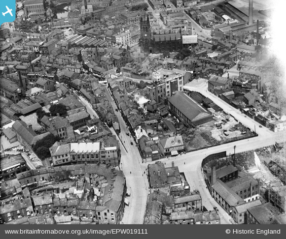
EPW019111 ENGLAND (1927). St Mary's Church and the Unicorn Brewery, Stockport, 1927
© Copyright OpenStreetMap contributors and licensed by the OpenStreetMap Foundation. 2026. Cartography is licensed as CC BY-SA.
Nearby Images (3)
EPW019111

EPW019112

EPW019113

Details
| Title | [EPW019111] St Mary's Church and the Unicorn Brewery, Stockport, 1927 |
| Reference | EPW019111 |
| Date | 4-August-1927 |
| Link | |
| Place name | STOCKPORT |
| Parish | |
| District | |
| Country | ENGLAND |
| Easting / Northing | 389760, 390366 |
| Longitude / Latitude | -2.1540617205186, 53.409747449741 |
| National Grid Reference | SJ898904 |
Pins

Kate Lamb |
Friday 19th of January 2018 10:47:58 PM | |
|
John Ellis |
Tuesday 7th of August 2012 10:19:48 PM | |
|
John Ellis |
Tuesday 7th of August 2012 10:18:14 PM | |
|
John Ellis |
Tuesday 7th of August 2012 10:17:05 PM | |
|
John Ellis |
Tuesday 7th of August 2012 10:14:40 PM | |
Robinsons Brewery now has stables on this road where they keep their two (occasionally three) Shire horses. You may also see one of them being trained pulling the brewery dray cart around Stockport town centre in the mornings. Also recommended is the Robinsons Visitor Centre on Apsley Street; highlighting the history of a family-run brewing company that is still going strong in 2017 and is fully operational, brewing good beer most days. In the visitor centre you can also join in a guided tour (fee payable- booking recommended) around the old Unicorn Brewery building. Robinsons Beer can be purchased with food in the Visitor Centre afterwards or do what we do which is just call in and have a bite to eat and enjoy a pint or two. |
Paula B |
Tuesday 14th of February 2017 07:05:41 PM |
|
John Ellis |
Tuesday 7th of August 2012 10:13:50 PM | |
|
John Ellis |
Tuesday 7th of August 2012 10:12:38 PM | |
|
John Ellis |
Tuesday 7th of August 2012 10:12:14 PM | |
|
totoro |
Monday 23rd of July 2012 09:54:06 PM | |
|
totoro |
Monday 23rd of July 2012 09:51:31 PM | |
|
totoro |
Monday 23rd of July 2012 09:45:34 PM | |
|
totoro |
Monday 23rd of July 2012 09:44:45 PM | |
|
totoro |
Monday 23rd of July 2012 09:41:49 PM | |
|
totoro |
Friday 22nd of June 2012 02:34:05 PM | |
|
totoro |
Friday 22nd of June 2012 02:33:25 PM | |
|
totoro |
Friday 22nd of June 2012 02:32:42 PM | |
Although most of the church was rebuilt in the early 19th century, the chancel dates back to around 1310 and there are small parts surviving from the original 12th century building. It is Grade I listed. |
John Ellis |
Tuesday 7th of August 2012 10:03:08 PM |
|
totoro |
Friday 22nd of June 2012 02:31:08 PM |