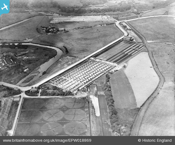
EPW018869 ENGLAND (1927). Hacken Outfall Sewage Works, Darcy Lever, 1927
© Copyright OpenStreetMap contributors and licensed by the OpenStreetMap Foundation. 2026. Cartography is licensed as CC BY-SA.
Nearby Images (8)
Details
| Title | [EPW018869] Hacken Outfall Sewage Works, Darcy Lever, 1927 |
| Reference | EPW018869 |
| Date | July-1927 |
| Link | |
| Place name | DARCY LEVER |
| Parish | |
| District | |
| Country | ENGLAND |
| Easting / Northing | 373633, 407630 |
| Longitude / Latitude | -2.3981400462713, 53.564378667342 |
| National Grid Reference | SD736076 |
Pins

pepsiboy |
Saturday 5th of July 2014 04:14:40 PM | |
Is Hacken Hall and Hacken Hall Farm one and the same? |

Dave Whenlock |
Monday 8th of September 2014 11:55:23 PM |

parrot |
Monday 20th of May 2013 05:50:06 PM | |

parrot |
Monday 20th of May 2013 05:47:39 PM |


![[EPW018869] Hacken Outfall Sewage Works, Darcy Lever, 1927](http://britainfromabove.org.uk/sites/all/libraries/aerofilms-images/public/100x100/EPW/018/EPW018869.jpg)
![[EPW018830] The Great Lever Bleach Works, Bolton, 1927](http://britainfromabove.org.uk/sites/all/libraries/aerofilms-images/public/100x100/EPW/018/EPW018830.jpg)
![[EPW018831] The Great Lever Bleach Works, Bolton, 1927](http://britainfromabove.org.uk/sites/all/libraries/aerofilms-images/public/100x100/EPW/018/EPW018831.jpg)
![[EPW018834] The Great Lever Bleach Works, Bolton, 1927](http://britainfromabove.org.uk/sites/all/libraries/aerofilms-images/public/100x100/EPW/018/EPW018834.jpg)
![[EPW018835] The Great Lever Bleach Works, Bolton, 1927](http://britainfromabove.org.uk/sites/all/libraries/aerofilms-images/public/100x100/EPW/018/EPW018835.jpg)
![[EPW018833] The Great Lever Bleach Works, Bolton, 1927](http://britainfromabove.org.uk/sites/all/libraries/aerofilms-images/public/100x100/EPW/018/EPW018833.jpg)
![[EPW018832] The Great Lever Bleach Works, Bolton, 1927](http://britainfromabove.org.uk/sites/all/libraries/aerofilms-images/public/100x100/EPW/018/EPW018832.jpg)
![[EPW018829] The Great Lever Bleach Works, Bolton, 1927](http://britainfromabove.org.uk/sites/all/libraries/aerofilms-images/public/100x100/EPW/018/EPW018829.jpg)