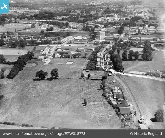
EPW018773 ENGLAND (1927). Construction of the Watling Estate, Edgware, 1927
© Copyright OpenStreetMap contributors and licensed by the OpenStreetMap Foundation. 2026. Cartography is licensed as CC BY-SA.
Nearby Images (30)
Details
| Title | [EPW018773] Construction of the Watling Estate, Edgware, 1927 |
| Reference | EPW018773 |
| Date | 8-July-1927 |
| Link | |
| Place name | EDGWARE |
| Parish | |
| District | |
| Country | ENGLAND |
| Easting / Northing | 519883, 190365 |
| Longitude / Latitude | -0.26892208628085, 51.598881115308 |
| National Grid Reference | TQ199904 |
Pins
User Comment Contributions
View looking east. |

Class31 |
Wednesday 22nd of August 2012 09:00:31 AM |


![[EPW018773] Construction of the Watling Estate, Edgware, 1927](http://britainfromabove.org.uk/sites/all/libraries/aerofilms-images/public/100x100/EPW/018/EPW018773.jpg)
![[EPW018771] Construction of the Watling Estate, Edgware, 1927](http://britainfromabove.org.uk/sites/all/libraries/aerofilms-images/public/100x100/EPW/018/EPW018771.jpg)
![[EPW018774] Construction of the Watling Estate, Edgware, 1927](http://britainfromabove.org.uk/sites/all/libraries/aerofilms-images/public/100x100/EPW/018/EPW018774.jpg)
![[EPW017583] Stag Lane, Queensbury, 1927](http://britainfromabove.org.uk/sites/all/libraries/aerofilms-images/public/100x100/EPW/017/EPW017583.jpg)
![[EPW022362] Stag Lane Aerodrome, Little Stanmore, from the north-east, 1928](http://britainfromabove.org.uk/sites/all/libraries/aerofilms-images/public/100x100/EPW/022/EPW022362.jpg)
![[EPW018767] The Watling Estate, Edgware, 1927](http://britainfromabove.org.uk/sites/all/libraries/aerofilms-images/public/100x100/EPW/018/EPW018767.jpg)
![[EPW018772] Construction of the Watling Estate, Edgware, 1927](http://britainfromabove.org.uk/sites/all/libraries/aerofilms-images/public/100x100/EPW/018/EPW018772.jpg)
![[EPW017584] Argyll Gardens and Kenmore Gardens under construction, Little Stanmore, 1927](http://britainfromabove.org.uk/sites/all/libraries/aerofilms-images/public/100x100/EPW/017/EPW017584.jpg)
![[EPW018768] Construction of the Watling Estate, Edgware, 1927](http://britainfromabove.org.uk/sites/all/libraries/aerofilms-images/public/100x100/EPW/018/EPW018768.jpg)
![[EPW018770] Construction of the Watling Estate, Queensbury, from the south, 1927](http://britainfromabove.org.uk/sites/all/libraries/aerofilms-images/public/100x100/EPW/018/EPW018770.jpg)
![[EPW018769] Construction of the Watling Estate, Edgware, 1927](http://britainfromabove.org.uk/sites/all/libraries/aerofilms-images/public/100x100/EPW/018/EPW018769.jpg)
![[EPW018766] Construction of the Watling Estate, Edgware, 1927](http://britainfromabove.org.uk/sites/all/libraries/aerofilms-images/public/100x100/EPW/018/EPW018766.jpg)
![[EPW015848] DH9A J7028 "Stag" undergoing flight trials at Stag Lane, Little Stanmore, 1926](http://britainfromabove.org.uk/sites/all/libraries/aerofilms-images/public/100x100/EPW/015/EPW015848.jpg)
![[EPW015849] DH9A J7028 "Stag" undergoing flight trials at Stag Lane, Little Stanmore, 1926](http://britainfromabove.org.uk/sites/all/libraries/aerofilms-images/public/100x100/EPW/015/EPW015849.jpg)
![[EPW015850] DH9A J7028 "Stag" undergoing flight trials at Stag Lane, Little Stanmore, 1926](http://britainfromabove.org.uk/sites/all/libraries/aerofilms-images/public/100x100/EPW/015/EPW015850.jpg)
![[EPW015851] DH9A J7028 "Stag" undergoing flight trials at Stag Lane, Little Stanmore, 1926](http://britainfromabove.org.uk/sites/all/libraries/aerofilms-images/public/100x100/EPW/015/EPW015851.jpg)
![[EPW015845] DH9A J7028 "Stag" undergoing flight trials at Stag Lane, Little Stanmore, 1926](http://britainfromabove.org.uk/sites/all/libraries/aerofilms-images/public/100x100/EPW/015/EPW015845.jpg)
![[EPW015847] DH9A J7028 "Stag" undergoing flight trials at Stag Lane, Little Stanmore, 1926](http://britainfromabove.org.uk/sites/all/libraries/aerofilms-images/public/100x100/EPW/015/EPW015847.jpg)
![[EPW034799] Stag Lane Aerodrome, Edgware Road and environs, Little Stanmore, from the south-east, 1931. This image has been produced from a damaged negative.](http://britainfromabove.org.uk/sites/all/libraries/aerofilms-images/public/100x100/EPW/034/EPW034799.jpg)
![[EPW015852] DH9A J7028 "Stag" undergoing flight trials at Stag Lane, Little Stanmore, 1926](http://britainfromabove.org.uk/sites/all/libraries/aerofilms-images/public/100x100/EPW/015/EPW015852.jpg)
![[EPW031546] Stag Lane Aerodrome and surroundings, Little Stanmore, from the south, 1930](http://britainfromabove.org.uk/sites/all/libraries/aerofilms-images/public/100x100/EPW/031/EPW031546.jpg)
![[EPW032891] The de Havilland Works at Stag Lane Aerodrome, Queensbury, from the north-east, 1930](http://britainfromabove.org.uk/sites/all/libraries/aerofilms-images/public/100x100/EPW/032/EPW032891.jpg)
![[EPW030056] The Youth of Britain at Stag Lane Aerodrome following Sir Alan Cobham's tour of Britain, 1929](http://britainfromabove.org.uk/sites/all/libraries/aerofilms-images/public/100x100/EPW/030/EPW030056.jpg)
![[EPW025691] Stag Lane Aerodrome, Little Stanmore, 1929](http://britainfromabove.org.uk/sites/all/libraries/aerofilms-images/public/100x100/EPW/025/EPW025691.jpg)
![[EPW046487] Housing estate under construction at the site of Stag Lane Aerodrome, Queensbury, from the south, 1935](http://britainfromabove.org.uk/sites/all/libraries/aerofilms-images/public/100x100/EPW/046/EPW046487.jpg)
![[EPW047555] The former works of De Havilland at Stag Lane, Queensbury, 1935](http://britainfromabove.org.uk/sites/all/libraries/aerofilms-images/public/100x100/EPW/047/EPW047555.jpg)
![[EPW047549] The former works of De Havilland at Stag Lane and housing at Holyrood Gardens and De Havilland Road, Queensbury, 1935](http://britainfromabove.org.uk/sites/all/libraries/aerofilms-images/public/100x100/EPW/047/EPW047549.jpg)
![[EPW047557] The former works of De Havilland at Stag Lane, Queensbury, 1935](http://britainfromabove.org.uk/sites/all/libraries/aerofilms-images/public/100x100/EPW/047/EPW047557.jpg)
![[EPW047554] The former works of De Havilland at Stag Lane, Queensbury, 1935](http://britainfromabove.org.uk/sites/all/libraries/aerofilms-images/public/100x100/EPW/047/EPW047554.jpg)
![[EPW019191] Barnfield Road, Burnt Oak, 1927](http://britainfromabove.org.uk/sites/all/libraries/aerofilms-images/public/100x100/EPW/019/EPW019191.jpg)