
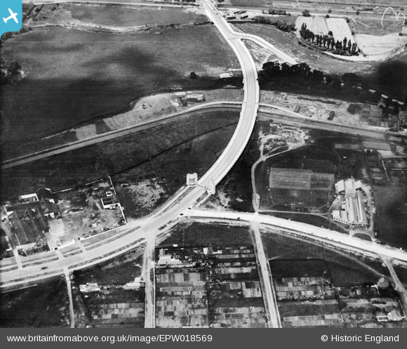
EPW018569 ENGLAND (1927). The Lea Valley Viaduct, Chingford, 1927
© Copyright OpenStreetMap contributors and licensed by the OpenStreetMap Foundation. 2026. Cartography is licensed as CC BY-SA.
Nearby Images (21)
EPW018569

EPW018563

EPW018562

EPW018564

EPW018561

EPW018572

EPW018568

EPW018656

EAW037671
 Factory, Flexo Plywood Works and the Cork Manufacturing Co Ltd Langite Works off Hall Lane, Chingford, 1951. This image has been produced from a print marked by Aerofilms Ltd for photo editing")
EAW037670
 Factory, Flexo Plywood Works and the Cork Manufacturing Co Ltd Langite Works off Hall Lane, Chingford, 1951. This image has been produced from a print marked by Aerofilms Ltd for photo editing")
EPW018570

EAW037672
 Factory and the Cork Manufacturing Co Ltd Langite Works off Hall Lane, Chingford, 1951. This image has been produced from a print marked by Aerofilms Ltd for photo editing.")
EPW056818

EAW037673
 Factory and the Cork Manufacturing Co Ltd Langite Works off Hall Lane, Chingford, 1951. This image has been produced from a print marked by Aerofilms Ltd for photo editing.")
EAW037675
 Factory and the Cork Manufacturing Co Ltd Langite Works off Hall Lane, Chingford, 1951. This image has been produced from a print marked by Aerofilms Ltd for photo editing.")
EPW053837

EAW037674
 Factory and the Cork Manufacturing Co Ltd Langite Works off Hall Lane, Chingford, 1951. This image has been produced from a print marked by Aerofilms Ltd for photo editing.")
EAW037676
 Factory and the Cork Manufacturing Co Ltd Langite Works off Hall Lane, Chingford, 1951. This image has been produced from a print marked by Aerofilms Ltd for photo editing.")
EPW056816

EPW056823

EPW052271

Details
| Title | [EPW018569] The Lea Valley Viaduct, Chingford, 1927 |
| Reference | EPW018569 |
| Date | June-1927 |
| Link | |
| Place name | CHINGFORD |
| Parish | |
| District | |
| Country | ENGLAND |
| Easting / Northing | 536313, 192163 |
| Longitude / Latitude | -0.031119989366421, 51.611302772964 |
| National Grid Reference | TQ363922 |
Pins
Be the first to add a comment to this image!