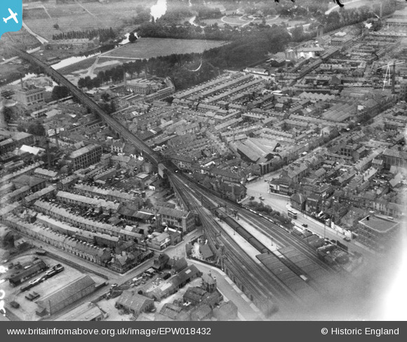
EPW018432 ENGLAND (1927). Central Station and environs, Leicester, 1927
© Copyright OpenStreetMap contributors and licensed by the OpenStreetMap Foundation. 2026. Cartography is licensed as CC BY-SA.
Nearby Images (12)
Details
| Title | [EPW018432] Central Station and environs, Leicester, 1927 |
| Reference | EPW018432 |
| Date | 10-June-1927 |
| Link | |
| Place name | LEICESTER |
| Parish | |
| District | |
| Country | ENGLAND |
| Easting / Northing | 458186, 305020 |
| Longitude / Latitude | -1.1400351804208, 52.639450512558 |
| National Grid Reference | SK582050 |
Pins

Carolyn |
Friday 25th of July 2014 12:50:11 PM | |

Jim Mitcho |
Friday 24th of January 2014 07:23:29 PM | |

Jim Mitcho |
Friday 24th of January 2014 07:10:16 PM | |

JCC |
Tuesday 8th of January 2013 10:36:26 PM | |

Shawn Sanders |
Friday 21st of December 2012 07:45:25 PM | |
Leicester North signal box. |

John Wass |
Tuesday 10th of February 2015 04:11:38 PM |

Underwood55 |
Tuesday 11th of December 2012 11:14:21 PM | |

Underwood55 |
Tuesday 11th of December 2012 11:11:31 PM |
User Comment Contributions
One of at least 3 Leicester stations at that time. If you zoom to the top right of the station you can clearly see "Great Central Hotel" painted on the roof of said building later to become the "Van Damme" strip club and to be demolished and left as an open site from the mid 80s until at least the present time of 2012 Much of this area is currently undergoing demolision pending redevelopment |

Timboishere |
Thursday 28th of June 2012 02:38:37 PM |


![[EPW018432] Central Station and environs, Leicester, 1927](http://britainfromabove.org.uk/sites/all/libraries/aerofilms-images/public/100x100/EPW/018/EPW018432.jpg)
![[EPW018430] Central Station, Leicester, 1927](http://britainfromabove.org.uk/sites/all/libraries/aerofilms-images/public/100x100/EPW/018/EPW018430.jpg)
![[EPW061206] Sanvey Gate and environs, Leicester, 1939](http://britainfromabove.org.uk/sites/all/libraries/aerofilms-images/public/100x100/EPW/061/EPW061206.jpg)
![[EAW052697] J & W Bastard Ltd Worsted Spinning Mill at Frog Island, Leicester, 1953. This image was marked by Aerofilms Ltd for photo editing.](http://britainfromabove.org.uk/sites/all/libraries/aerofilms-images/public/100x100/EAW/052/EAW052697.jpg)
![[EAW052690] J & W Bastard Ltd Worsted Spinning Mill at Frog Island, Leicester, 1953. This image was marked by Aerofilms Ltd for photo editing.](http://britainfromabove.org.uk/sites/all/libraries/aerofilms-images/public/100x100/EAW/052/EAW052690.jpg)
![[EPW047644] The city centre, Leicester, from the north-west, 1935](http://britainfromabove.org.uk/sites/all/libraries/aerofilms-images/public/100x100/EPW/047/EPW047644.jpg)
![[EAW052696] J & W Bastard Ltd Worsted Spinning Mill at Frog Island, Leicester, 1953. This image was marked by Aerofilms Ltd for photo editing.](http://britainfromabove.org.uk/sites/all/libraries/aerofilms-images/public/100x100/EAW/052/EAW052696.jpg)
![[EAW052695] J & W Bastard Ltd Worsted Spinning Mill at Frog Island, Leicester, 1953. This image was marked by Aerofilms Ltd for photo editing.](http://britainfromabove.org.uk/sites/all/libraries/aerofilms-images/public/100x100/EAW/052/EAW052695.jpg)
![[EAW052693] J & W Bastard Ltd Worsted Spinning Mill at Frog Island, Leicester, 1953. This image was marked by Aerofilms Ltd for photo editing.](http://britainfromabove.org.uk/sites/all/libraries/aerofilms-images/public/100x100/EAW/052/EAW052693.jpg)
![[EAW052694] J & W Bastard Ltd Worsted Spinning Mill at Frog Island, Leicester, 1953. This image was marked by Aerofilms Ltd for photo editing.](http://britainfromabove.org.uk/sites/all/libraries/aerofilms-images/public/100x100/EAW/052/EAW052694.jpg)
![[EAW052691] J & W Bastard Ltd Worsted Spinning Mill at Frog Island, Leicester, 1953. This image was marked by Aerofilms Ltd for photo editing.](http://britainfromabove.org.uk/sites/all/libraries/aerofilms-images/public/100x100/EAW/052/EAW052691.jpg)
![[EAW052692] J & W Bastard Ltd Worsted Spinning Mill at Frog Island, Leicester, 1953. This image was marked by Aerofilms Ltd for photo editing.](http://britainfromabove.org.uk/sites/all/libraries/aerofilms-images/public/100x100/EAW/052/EAW052692.jpg)