
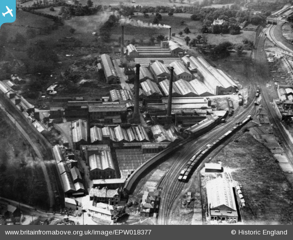
EPW018377 ENGLAND (1927). The King's Norton Metal Works (later Birmingham Factory Centre), King's Norton, 1927. This image has been produced from a copy-negative.
© Copyright OpenStreetMap contributors and licensed by the OpenStreetMap Foundation. 2026. Cartography is licensed as CC BY-SA.
Nearby Images (5)
EPW018377
, King's Norton, 1927. This image has been produced from a copy-negative.")
EPW050079

EPW050078

EPW050080

EPW018368
, Cotteridge Road and environs, Cotteridge, from the north-west, 1927. This image has been produced from a copy-negative.")
Details
| Title | [EPW018377] The King's Norton Metal Works (later Birmingham Factory Centre), King's Norton, 1927. This image has been produced from a copy-negative. |
| Reference | EPW018377 |
| Date | 10-June-1927 |
| Link | |
| Place name | KING'S NORTON |
| Parish | |
| District | |
| Country | ENGLAND |
| Easting / Northing | 405341, 279749 |
| Longitude / Latitude | -1.9214637912558, 52.415335124275 |
| National Grid Reference | SP053797 |
Pins

Ilwertornram4 |
Monday 10th of February 2025 09:21:31 AM | |
|
Ilwertornram4 |
Monday 10th of February 2025 09:20:02 AM | |
|
Ilwertornram4 |
Monday 10th of February 2025 09:17:11 AM | |
|
Ilwertornram4 |
Monday 10th of February 2025 09:15:33 AM | |
|
Ilwertornram4 |
Monday 10th of February 2025 09:14:49 AM | |
|
Bryan |
Monday 12th of October 2015 10:01:49 PM |
User Comment Contributions
Pin shows approximate Kings Norton Mint building |
Bryan |
Monday 12th of October 2015 10:03:54 PM |