
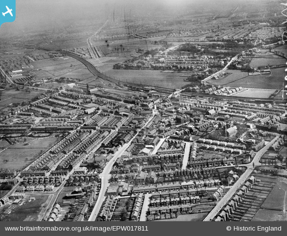
EPW017811 ENGLAND (1927). The town centre, Stretford, from the west, 1927
© Copyright OpenStreetMap contributors and licensed by the OpenStreetMap Foundation. 2026. Cartography is licensed as CC BY-SA.
Nearby Images (5)
EPW017811

EPW038541

EPW038542

EPW038543

EPW028116

Details
| Title | [EPW017811] The town centre, Stretford, from the west, 1927 |
| Reference | EPW017811 |
| Date | April-1927 |
| Link | |
| Place name | STRETFORD |
| Parish | |
| District | |
| Country | ENGLAND |
| Easting / Northing | 379377, 394331 |
| Longitude / Latitude | -2.3105326582024, 53.445086899791 |
| National Grid Reference | SJ794943 |
Pins

Rick |
Tuesday 3rd of April 2018 11:06:47 PM | |
|
phloberts |
Saturday 12th of August 2017 09:14:12 PM | |
|
Stretfordian |
Thursday 21st of April 2016 10:24:38 PM | |
|
Stretfordian |
Thursday 21st of April 2016 10:23:53 PM | |
|
Stretfordian |
Thursday 21st of April 2016 10:22:33 PM | |
|
Stretfordian |
Thursday 21st of April 2016 10:20:41 PM | |
|
Stretfordian |
Thursday 21st of April 2016 10:17:31 PM | |
|
Stretfordian |
Sunday 31st of January 2016 09:42:44 PM | |
|
maxwell |
Thursday 24th of December 2015 01:14:22 PM | |
|
maxwell |
Thursday 24th of December 2015 01:12:25 PM | |
|
Stretfordian |
Saturday 21st of November 2015 01:01:54 AM | |
|
Andrew |
Thursday 17th of October 2013 02:40:23 PM | |
|
Rick |
Saturday 27th of July 2013 01:25:20 PM | |
|
phloberts |
Friday 24th of May 2013 05:01:13 PM | |
Here we watched Old Mother Riley films on a Saturday morning |
Ros |
Tuesday 5th of August 2014 05:46:15 PM |
|
John Ellis |
Sunday 18th of November 2012 05:48:25 PM | |
|
John Ellis |
Sunday 18th of November 2012 05:45:56 PM | |
|
John Ellis |
Sunday 18th of November 2012 05:44:16 PM | |
|
John Ellis |
Sunday 18th of November 2012 05:43:53 PM | |
|
John Ellis |
Sunday 18th of November 2012 05:41:42 PM | |
|
John Ellis |
Sunday 18th of November 2012 05:39:40 PM | |
|
John Ellis |
Sunday 18th of November 2012 05:39:04 PM | |
|
John Ellis |
Sunday 18th of November 2012 05:38:10 PM | |
|
John Ellis |
Sunday 18th of November 2012 05:36:10 PM | |
|
John Ellis |
Sunday 18th of November 2012 05:34:53 PM | |
|
John Ellis |
Sunday 18th of November 2012 05:31:57 PM | |
|
John Ellis |
Sunday 18th of November 2012 05:28:34 PM | |
|
John Ellis |
Sunday 18th of November 2012 05:27:43 PM | |
|
John Ellis |
Sunday 18th of November 2012 05:26:55 PM | |
|
John Ellis |
Sunday 18th of November 2012 05:24:01 PM | |
|
John Ellis |
Sunday 18th of November 2012 05:23:03 PM | |
|
John Ellis |
Sunday 18th of November 2012 05:20:27 PM | |
|
John Ellis |
Sunday 18th of November 2012 05:20:04 PM | |
|
John Ellis |
Sunday 18th of November 2012 05:17:24 PM | |
|
John Ellis |
Sunday 18th of November 2012 05:16:43 PM | |
|
John Ellis |
Sunday 18th of November 2012 05:06:02 PM |