
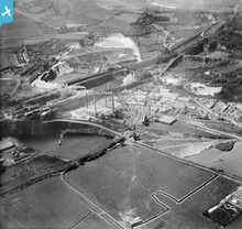
EPW017659 ENGLAND (1927). The Portland Cement Works, Swanscombe, 1927

© Copyright OpenStreetMap contributors and licensed by the OpenStreetMap Foundation. 2026. Cartography is licensed as CC BY-SA.
Nearby Images (12)
EPW017659

EPW060600

EPW060597

EPW060599

EPW060601

EPW060598

EPW017658

EPW060592

EPW060594

EPW060593

EPW060596

EPW060595

Details
| Title | [EPW017659] The Portland Cement Works, Swanscombe, 1927 |
| Reference | EPW017659 |
| Date | April-1927 |
| Link | |
| Place name | SWANSCOMBE |
| Parish | SWANSCOMBE AND GREENHITHE |
| District | |
| Country | ENGLAND |
| Easting / Northing | 560264, 175162 |
| Longitude / Latitude | 0.30680576111345, 51.452237775213 |
| National Grid Reference | TQ603752 |
Pins

Dylan Moore |
Tuesday 19th of February 2019 04:43:56 PM | |
|
Dylan Moore |
Monday 17th of November 2014 04:57:59 PM | |
|
Dylan Moore |
Monday 17th of November 2014 04:57:24 PM | |
|
Dylan Moore |
Monday 17th of November 2014 04:56:55 PM | |
|
Dylan Moore |
Monday 17th of November 2014 04:54:27 PM | |
|
Dylan Moore |
Friday 19th of April 2013 09:15:38 PM | |
|
Dylan Moore |
Tuesday 16th of October 2012 05:03:29 PM | |
|
Dylan Moore |
Tuesday 16th of October 2012 05:02:41 PM |
User Comment Contributions
For details and many links, see [[http://www.cementkilns.co.uk/cement_kiln_swanscombe.html]]. |
Dylan Moore |
Thursday 18th of October 2012 08:56:14 PM |
What's that complex to the right of the kiln house? Beats me! |
Dylan Moore |
Tuesday 16th of October 2012 11:23:50 PM |
This shows Swanscombe Cement Plant prior to its rebuild in 1928-29. With 14 operating rotary kilns, it was Britain’s biggest plant until the rebuild of the Bevans plant in 1926. Chalk was originally quarried on the north side of the London road, and subsequent quarries were developed to the south until Swanscombe village was surrounded on its south side. |
Dylan Moore |
Tuesday 16th of October 2012 05:10:40 PM |