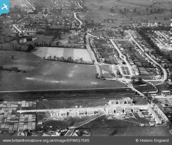
EPW017565 ENGLAND (1927). The Gidea Park Estate, Gidea Park, from the south-east, 1927
© Copyright OpenStreetMap contributors and licensed by the OpenStreetMap Foundation. 2025. Cartography is licensed as CC BY-SA.
Details
| Title | [EPW017565] The Gidea Park Estate, Gidea Park, from the south-east, 1927 |
| Reference | EPW017565 |
| Date | 12-April-1927 |
| Link | |
| Place name | GIDEA PARK |
| Parish | |
| District | |
| Country | ENGLAND |
| Easting / Northing | 552676, 189152 |
| Longitude / Latitude | 0.20373550990341, 51.580046970315 |
| National Grid Reference | TQ527892 |
Pins
 GeoffR |
Friday 16th of January 2015 05:22:23 PM | |
 GeoffR |
Friday 16th of January 2015 05:22:18 PM | |
 Pessoa |
Monday 11th of November 2013 02:25:34 PM | |
 Class31 |
Sunday 31st of March 2013 05:47:13 PM | |
 Class31 |
Sunday 31st of March 2013 05:46:00 PM | |
 Class31 |
Sunday 31st of March 2013 05:38:59 PM | |
 Class31 |
Sunday 31st of March 2013 05:29:38 PM | |
 Class31 |
Sunday 31st of March 2013 05:23:40 PM |
User Comment Contributions
I used to live here! The three roads are Balgores Lane, Squirrels Heath Avenue and Crossways on the right. You can see the tennis courts mid front of the picture with the train line below, and Gidea Park station is just on the lower right. Amazing to see such bare gardens as the streets were tree lined when I was a child in the 50's. |
 Charmian |
Tuesday 26th of June 2012 12:21:59 AM |


![[EPW017565] The Gidea Park Estate, Gidea Park, from the south-east, 1927](http://britainfromabove.org.uk/sites/all/libraries/aerofilms-images/public/100x100/EPW/017/EPW017565.jpg)
![[EPW017576] The Gidea Park Estate and Romford Golf Course, Gidea Park, from the south, 1927](http://britainfromabove.org.uk/sites/all/libraries/aerofilms-images/public/100x100/EPW/017/EPW017576.jpg)
![[EPW017572] Balgores Square and the railway station, Gidea Park, 1927](http://britainfromabove.org.uk/sites/all/libraries/aerofilms-images/public/100x100/EPW/017/EPW017572.jpg)
![[EPW017571] The Gidea Park Estate and Romford Golf Course, Gidea Park, from the south-east, 1927](http://britainfromabove.org.uk/sites/all/libraries/aerofilms-images/public/100x100/EPW/017/EPW017571.jpg)