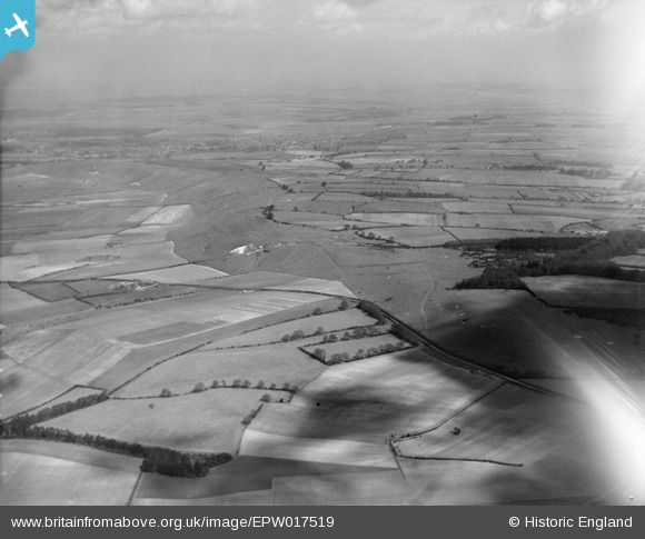
EPW017519 ENGLAND (1927). The Whipsnade Estate, Whipsnade, from the south-west, 1927
© Copyright OpenStreetMap contributors and licensed by the OpenStreetMap Foundation. 2026. Cartography is licensed as CC BY-SA.
Nearby Images (15)
Details
| Title | [EPW017519] The Whipsnade Estate, Whipsnade, from the south-west, 1927 |
| Reference | EPW017519 |
| Date | March-1927 |
| Link | |
| Place name | WHIPSNADE |
| Parish | WHIPSNADE |
| District | |
| Country | ENGLAND |
| Easting / Northing | 499462, 217879 |
| Longitude / Latitude | -0.55582452476434, 51.850190528963 |
| National Grid Reference | SP995179 |
Pins
Be the first to add a comment to this image!


![[EPW017519] The Whipsnade Estate, Whipsnade, from the south-west, 1927](http://britainfromabove.org.uk/sites/all/libraries/aerofilms-images/public/100x100/EPW/017/EPW017519.jpg)
![[EAW003414] The Whipsnade Lion chalk hill figure, Whipsnade, from the north-west, 1946](http://britainfromabove.org.uk/sites/all/libraries/aerofilms-images/public/100x100/EAW/003/EAW003414.jpg)
![[EPW017516] The Whipsnade Estate, Whipsnade, from the west, 1927](http://britainfromabove.org.uk/sites/all/libraries/aerofilms-images/public/100x100/EPW/017/EPW017516.jpg)
![[EPW040713] The Whipsnade Lion chalk hill figure under construction, Whipsnade, 1932. This image was marked by Aerofilms Ltd for photo editing.](http://britainfromabove.org.uk/sites/all/libraries/aerofilms-images/public/100x100/EPW/040/EPW040713.jpg)
![[EPW040714] The Whipsnade Lion chalk hill figure under construction, Whipsnade, 1932](http://britainfromabove.org.uk/sites/all/libraries/aerofilms-images/public/100x100/EPW/040/EPW040714.jpg)
![[EPW040715] The Whipsnade Lion chalk hill figure under construction, Whipsnade, 1932](http://britainfromabove.org.uk/sites/all/libraries/aerofilms-images/public/100x100/EPW/040/EPW040715.jpg)
![[EAW037779] The Whipsnade White Lion chalk hill figure, Whipsnade, 1951](http://britainfromabove.org.uk/sites/all/libraries/aerofilms-images/public/100x100/EAW/037/EAW037779.jpg)
![[EPW040710] The Whipsnade Lion chalk hill figure under construction, Whipsnade, 1932](http://britainfromabove.org.uk/sites/all/libraries/aerofilms-images/public/100x100/EPW/040/EPW040710.jpg)
![[EAW037780] The Whipsnade White Lion chalk hill figure, Whipsnade, 1951](http://britainfromabove.org.uk/sites/all/libraries/aerofilms-images/public/100x100/EAW/037/EAW037780.jpg)
![[EPW040709] The Whipsnade Lion chalk hill figure under construction, Whipsnade, 1932](http://britainfromabove.org.uk/sites/all/libraries/aerofilms-images/public/100x100/EPW/040/EPW040709.jpg)
![[EPW040712] The Whipsnade Lion chalk hill figure under construction, Whipsnade, 1932](http://britainfromabove.org.uk/sites/all/libraries/aerofilms-images/public/100x100/EPW/040/EPW040712.jpg)
![[EAW014236] The Whipsnade White Lion chalk hill figure, Whipsnade, 1948](http://britainfromabove.org.uk/sites/all/libraries/aerofilms-images/public/100x100/EAW/014/EAW014236.jpg)
![[EPW040711] The Whipsnade Lion chalk hill figure under construction, Whipsnade, 1932](http://britainfromabove.org.uk/sites/all/libraries/aerofilms-images/public/100x100/EPW/040/EPW040711.jpg)
![[EAW014233] The Whipsnade White Lion chalk hill figure, Whipsnade, 1948](http://britainfromabove.org.uk/sites/all/libraries/aerofilms-images/public/100x100/EAW/014/EAW014233.jpg)
![[EAW014232] The Whipsnade White Lion chalk hill figure, Whipsnade, 1948](http://britainfromabove.org.uk/sites/all/libraries/aerofilms-images/public/100x100/EAW/014/EAW014232.jpg)