
EPW017450 ENGLAND (1927). Poundswick and Brownley Green, Manchester, from the west, 1927

© Copyright OpenStreetMap contributors and licensed by the OpenStreetMap Foundation. 2026. Cartography is licensed as CC BY-SA.
Details
| Title | [EPW017450] Poundswick and Brownley Green, Manchester, from the west, 1927 |
| Reference | EPW017450 |
| Date | 8-March-1927 |
| Link | |
| Place name | MANCHESTER |
| Parish | |
| District | |
| Country | ENGLAND |
| Easting / Northing | 382192, 387198 |
| Longitude / Latitude | -2.2677430875802, 53.381067489599 |
| National Grid Reference | SJ822872 |
Pins

Brian Lea |
Thursday 7th of December 2017 02:43:48 PM | |
|
John Ellis |
Tuesday 28th of July 2015 05:52:00 PM | |
|
Cancan |
Saturday 18th of October 2014 06:46:49 PM | |
|
Cancan |
Saturday 19th of July 2014 12:01:05 AM | |
|
Cancan |
Friday 18th of July 2014 11:48:28 PM | |
|
TheGuvOfWythenshawe |
Friday 24th of January 2014 05:51:34 AM | |
|
TheGuvOfWythenshawe |
Friday 24th of January 2014 05:48:48 AM | |
|
TheGuvOfWythenshawe |
Friday 24th of January 2014 05:45:42 AM | |
|
TheGuvOfWythenshawe |
Friday 24th of January 2014 05:43:42 AM | |
|
TheGuvOfWythenshawe |
Friday 24th of January 2014 05:39:37 AM | |
|
TheGuvOfWythenshawe |
Friday 24th of January 2014 05:37:38 AM | |
|
TheGuvOfWythenshawe |
Friday 24th of January 2014 05:34:58 AM | |
|
TheGuvOfWythenshawe |
Friday 24th of January 2014 05:31:20 AM | |
You're right. I was trying to use just one "peg" for the whole of the Civic, bus station included. Bit slothful, really ... |
John Ellis |
Friday 24th of January 2014 03:41:55 PM |
|
RDC |
Friday 15th of November 2013 04:57:53 PM | |
|
John Ellis |
Friday 12th of October 2012 05:50:36 PM | |
|
John Ellis |
Sunday 22nd of July 2012 03:12:17 PM | |
|
John Ellis |
Sunday 22nd of July 2012 03:10:33 PM | |
|
John Ellis |
Sunday 22nd of July 2012 03:09:18 PM | |
|
John Ellis |
Sunday 22nd of July 2012 03:04:51 PM | |
|
John Ellis |
Sunday 22nd of July 2012 03:03:55 PM | |
|
John Ellis |
Sunday 22nd of July 2012 03:03:10 PM | |
|
John Ellis |
Sunday 22nd of July 2012 02:59:34 PM | |
|
John Ellis |
Sunday 22nd of July 2012 02:58:19 PM | |
|
John Ellis |
Sunday 22nd of July 2012 02:57:22 PM | |
|
John Ellis |
Sunday 22nd of July 2012 02:56:09 PM | |
|
John Ellis |
Sunday 22nd of July 2012 02:54:27 PM | |
|
John Ellis |
Sunday 22nd of July 2012 02:52:58 PM | |
|
John Ellis |
Sunday 22nd of July 2012 02:51:38 PM | |
|
John Ellis |
Sunday 22nd of July 2012 02:49:26 PM | |
|
John Ellis |
Sunday 22nd of July 2012 02:47:51 PM | |
|
John Ellis |
Sunday 22nd of July 2012 02:45:07 PM | |
|
John Ellis |
Sunday 22nd of July 2012 02:44:28 PM | |
|
John Ellis |
Sunday 22nd of July 2012 02:43:14 PM | |
|
John Ellis |
Sunday 22nd of July 2012 02:41:53 PM | |
|
John Ellis |
Sunday 22nd of July 2012 02:40:59 PM | |
|
John Ellis |
Sunday 22nd of July 2012 02:39:03 PM | |
|
John Ellis |
Sunday 22nd of July 2012 02:37:36 PM | |
|
John Ellis |
Sunday 22nd of July 2012 02:36:09 PM | |
|
John Ellis |
Sunday 22nd of July 2012 02:34:53 PM | |
|
John Ellis |
Sunday 22nd of July 2012 02:30:53 PM |


User Comment Contributions
This area was not in fact incorporated into Manchester until the early 1930s. At this time it was still part of the civil parish of Northen Etchells in the Bucklow Rural District (headquartered in Knutsford) of the county of Cheshire. |
John Ellis |
Wednesday 29th of July 2015 04:30:30 PM |
Dear John Brilliant! - thank you for your help in identifying the location of this image. We'll update the details when the next data upload to the website takes place. Best wishes Laura Maddison Britain from ABove Cataloguer |

Laura Maddison |
Wednesday 12th of September 2012 08:53:06 PM |
Glad to have been of help. I've no memory of this area when it was open countryside, as Brownley Green was one of the first areas of the Wythenshawe estate to be developed with housing, only a year or two after this picture was taken. But maps of the period show that the hamlet of Brownley Green had a distinctively shaped village green at its centre, and that, along with the proximity of Park Wood - which still exists - just to the east, made the identification pretty easy. After that, the other landscape features fell into place and made the location unambiguous. |
John Ellis |
Wednesday 12th of September 2012 08:53:06 PM |
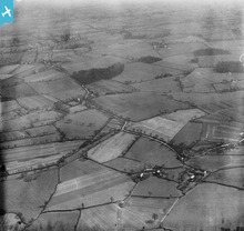
The only "unlocated" shot in the particular flight in April 1927 which covered the localities south of Manchester. The camera takes in a view to the east, with the then hamlet of Poundswick (it was just west of the present Wythenshawe Civic Centre) in the foreground, Brownley Green in the middle distance, Crossacres beyond, and with the line of Styal Road at the top of the photograph. |
John Ellis |
Sunday 22nd of July 2012 03:37:57 PM |
This is likely to be in Cheshire from the adjoining image locations. Somewhere in the Altrincham area perhaps. |

Class31 |
Monday 9th of July 2012 08:56:48 AM |