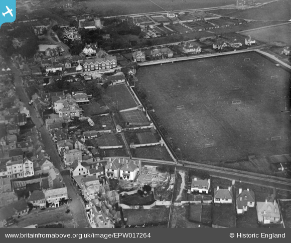
EPW017264 ENGLAND (1926). St Aubyns School playing field and environs, Rottingdean, 1926
© Copyright OpenStreetMap contributors and licensed by the OpenStreetMap Foundation. 2026. Cartography is licensed as CC BY-SA.
Nearby Images (36)
Details
| Title | [EPW017264] St Aubyns School playing field and environs, Rottingdean, 1926 |
| Reference | EPW017264 |
| Date | 26-October-1926 |
| Link | |
| Place name | ROTTINGDEAN |
| Parish | ROTTINGDEAN |
| District | |
| Country | ENGLAND |
| Easting / Northing | 537041, 102302 |
| Longitude / Latitude | -0.054945665002817, 50.803484149171 |
| National Grid Reference | TQ370023 |
Pins
Be the first to add a comment to this image!


![[EPW017264] St Aubyns School playing field and environs, Rottingdean, 1926](http://britainfromabove.org.uk/sites/all/libraries/aerofilms-images/public/100x100/EPW/017/EPW017264.jpg)
![[EPW018063] St Aubyns School, Rottingdean, 1927](http://britainfromabove.org.uk/sites/all/libraries/aerofilms-images/public/100x100/EPW/018/EPW018063.jpg)
![[EPW018054] St Aubyns School, Rottingdean, 1927](http://britainfromabove.org.uk/sites/all/libraries/aerofilms-images/public/100x100/EPW/018/EPW018054.jpg)
![[EPW017265] St Aubyns School, the playing field and environs, Rottingdean, 1926](http://britainfromabove.org.uk/sites/all/libraries/aerofilms-images/public/100x100/EPW/017/EPW017265.jpg)
![[EPW017269] St Aubyns School, the playing field and environs, Rottingdean, 1926](http://britainfromabove.org.uk/sites/all/libraries/aerofilms-images/public/100x100/EPW/017/EPW017269.jpg)
![[EPW017268] St Aubyns School and playing field, Rottingdean, 1926](http://britainfromabove.org.uk/sites/all/libraries/aerofilms-images/public/100x100/EPW/017/EPW017268.jpg)
![[EPW017266] St Aubyns School, the playing field and environs, Rottingdean, 1926](http://britainfromabove.org.uk/sites/all/libraries/aerofilms-images/public/100x100/EPW/017/EPW017266.jpg)
![[EPW017270] St Aubyns School, Rottingdean, 1926](http://britainfromabove.org.uk/sites/all/libraries/aerofilms-images/public/100x100/EPW/017/EPW017270.jpg)
![[EPW017267] St Aubyns School, Rottingdean, 1926](http://britainfromabove.org.uk/sites/all/libraries/aerofilms-images/public/100x100/EPW/017/EPW017267.jpg)
![[EPW018059] St Aubyns School, Rottingdean, 1927](http://britainfromabove.org.uk/sites/all/libraries/aerofilms-images/public/100x100/EPW/018/EPW018059.jpg)
![[EPW017263] St Aubyns School and playing field, Rottingdean, 1926](http://britainfromabove.org.uk/sites/all/libraries/aerofilms-images/public/100x100/EPW/017/EPW017263.jpg)
![[EPW018057] St Aubyns School, Rottingdean, 1927](http://britainfromabove.org.uk/sites/all/libraries/aerofilms-images/public/100x100/EPW/018/EPW018057.jpg)
![[EPW054058] The village, Rottingdean, from the south-east, 1937](http://britainfromabove.org.uk/sites/all/libraries/aerofilms-images/public/100x100/EPW/054/EPW054058.jpg)
![[EPW017731] St Aubyns School playing field and environs, Rottingdean, 1927](http://britainfromabove.org.uk/sites/all/libraries/aerofilms-images/public/100x100/EPW/017/EPW017731.jpg)
![[EPW042967] St Aubyn's Playing Field, Rottingdean Heights and environs, Rottingdean, 1933](http://britainfromabove.org.uk/sites/all/libraries/aerofilms-images/public/100x100/EPW/042/EPW042967.jpg)
![[EPW018056] St Aubyns School, Rottingdean, 1927](http://britainfromabove.org.uk/sites/all/libraries/aerofilms-images/public/100x100/EPW/018/EPW018056.jpg)
![[EPW017726] St Aubyns School playing field and environs, Rottingdean, 1927](http://britainfromabove.org.uk/sites/all/libraries/aerofilms-images/public/100x100/EPW/017/EPW017726.jpg)
![[EPW042966] High Street and environs, Rottingdean, 1933](http://britainfromabove.org.uk/sites/all/libraries/aerofilms-images/public/100x100/EPW/042/EPW042966.jpg)
![[EPW017727] St Aubyns School and playing field, Rottingdean, 1927](http://britainfromabove.org.uk/sites/all/libraries/aerofilms-images/public/100x100/EPW/017/EPW017727.jpg)
![[EPW018062] St Aubyns School playing field and environs, Rottingdean, 1927](http://britainfromabove.org.uk/sites/all/libraries/aerofilms-images/public/100x100/EPW/018/EPW018062.jpg)
![[EPW017728] St Aubyns School playing field and environs, Rottingdean, 1927](http://britainfromabove.org.uk/sites/all/libraries/aerofilms-images/public/100x100/EPW/017/EPW017728.jpg)
![[EPW035301] The High Street and the village, Rottingdean, 1931](http://britainfromabove.org.uk/sites/all/libraries/aerofilms-images/public/100x100/EPW/035/EPW035301.jpg)
![[EPW017734] St Aubyns School and playing field, Rottingdean, 1927](http://britainfromabove.org.uk/sites/all/libraries/aerofilms-images/public/100x100/EPW/017/EPW017734.jpg)
![[EPW035300] St Aubyn's Playing Field and area around Marine Drive, Rottingdean, 1931](http://britainfromabove.org.uk/sites/all/libraries/aerofilms-images/public/100x100/EPW/035/EPW035300.jpg)
![[EPW035299] The village, Rottingdean, 1931. This image has been produced from a copy-negative.](http://britainfromabove.org.uk/sites/all/libraries/aerofilms-images/public/100x100/EPW/035/EPW035299.jpg)
![[EPW018058] St Aubyns School, Rottingdean, from the north-west, 1927](http://britainfromabove.org.uk/sites/all/libraries/aerofilms-images/public/100x100/EPW/018/EPW018058.jpg)
![[EAW024795] Chalk cliffs between Rottingdean and Brighton, Rottingdean, from the south-east, 1949](http://britainfromabove.org.uk/sites/all/libraries/aerofilms-images/public/100x100/EAW/024/EAW024795.jpg)
![[EPW017730] St Aubyns School playing field and environs, Rottingdean, from the south, 1927](http://britainfromabove.org.uk/sites/all/libraries/aerofilms-images/public/100x100/EPW/017/EPW017730.jpg)
![[EPW018055] St Aubyns School playing field and environs, Rottingdean, from the north-west, 1927](http://britainfromabove.org.uk/sites/all/libraries/aerofilms-images/public/100x100/EPW/018/EPW018055.jpg)
![[EPW017732] St Aubyns School playing field and environs, Rottingdean, from the east, 1927](http://britainfromabove.org.uk/sites/all/libraries/aerofilms-images/public/100x100/EPW/017/EPW017732.jpg)
![[EPW018064] St Aubyns School and environs, Rottingdean, from the west, 1927](http://britainfromabove.org.uk/sites/all/libraries/aerofilms-images/public/100x100/EPW/018/EPW018064.jpg)
![[EPW017733] St Aubyns School playing field and environs, Rottingdean, from the north, 1927](http://britainfromabove.org.uk/sites/all/libraries/aerofilms-images/public/100x100/EPW/017/EPW017733.jpg)
![[EAW024794] Chalk cliffs between Rottingdean and Brighton, Rottingdean, from the south-east, 1949](http://britainfromabove.org.uk/sites/all/libraries/aerofilms-images/public/100x100/EAW/024/EAW024794.jpg)
![[EPW018061] St Aubyns School playing field and environs, Rottingdean, from the north-west, 1927](http://britainfromabove.org.uk/sites/all/libraries/aerofilms-images/public/100x100/EPW/018/EPW018061.jpg)
![[EPW041382] The village, Rottingdean, 1933](http://britainfromabove.org.uk/sites/all/libraries/aerofilms-images/public/100x100/EPW/041/EPW041382.jpg)
![[EPW054004] St Martha's Convent and environs including North End House, Rottingdean, 1937](http://britainfromabove.org.uk/sites/all/libraries/aerofilms-images/public/100x100/EPW/054/EPW054004.jpg)