
EPW016792 ENGLAND (1926). The Rochdale Branch canal basin, warehouses and environs, Rochdale, 1926

© Copyright OpenStreetMap contributors and licensed by the OpenStreetMap Foundation. 2026. Cartography is licensed as CC BY-SA.
Details
| Title | [EPW016792] The Rochdale Branch canal basin, warehouses and environs, Rochdale, 1926 |
| Reference | EPW016792 |
| Date | August-1926 |
| Link | |
| Place name | ROCHDALE |
| Parish | |
| District | |
| Country | ENGLAND |
| Easting / Northing | 389851, 412938 |
| Longitude / Latitude | -2.1534237203333, 53.61265823062 |
| National Grid Reference | SD899129 |
Pins
User Comment Contributions
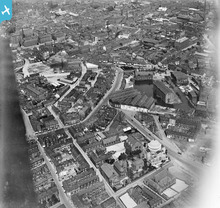
This clearly shows the extensive warehousing at the basin at the end of the Rochdale Branch of the Rochdale Canal. Almost an inland port. All this has long gone. |

Frank S |
Saturday 30th of June 2012 04:31:02 PM |