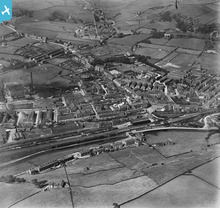
EPW016768 ENGLAND (1926). Hare Hill Road and the town centre, Littleborough, 1926
© Copyright OpenStreetMap contributors and licensed by the OpenStreetMap Foundation. 2026. Cartography is licensed as CC BY-SA.
Nearby Images (6)
Details
| Title | [EPW016768] Hare Hill Road and the town centre, Littleborough, 1926 |
| Reference | EPW016768 |
| Date | August-1926 |
| Link | |
| Place name | LITTLEBOROUGH |
| Parish | |
| District | |
| Country | ENGLAND |
| Easting / Northing | 393662, 416322 |
| Longitude / Latitude | -2.0958813947651, 53.643137857431 |
| National Grid Reference | SD937163 |
Pins

bobmunc |
Saturday 30th of July 2022 09:35:18 PM | |

Izzy |
Tuesday 29th of May 2018 02:05:17 PM | |

Weathervane |
Wednesday 18th of July 2012 09:11:23 AM | |

Weathervane |
Wednesday 18th of July 2012 09:01:46 AM | |

Weathervane |
Wednesday 18th of July 2012 08:54:14 AM | |

Weathervane |
Wednesday 18th of July 2012 08:50:35 AM | |

Refelt |
Tuesday 17th of July 2012 11:11:26 AM | |

Refelt |
Tuesday 17th of July 2012 11:09:35 AM | |

Refelt |
Tuesday 17th of July 2012 11:00:41 AM | |

Refelt |
Tuesday 17th of July 2012 10:57:02 AM | |

Refelt |
Tuesday 17th of July 2012 10:55:00 AM | |

Refelt |
Tuesday 17th of July 2012 10:46:57 AM | |

Refelt |
Tuesday 17th of July 2012 10:45:06 AM | |

Refelt |
Tuesday 17th of July 2012 10:41:16 AM | |

Refelt |
Tuesday 17th of July 2012 10:37:59 AM | |

Weathervane |
Monday 16th of July 2012 04:41:39 PM | |

Weathervane |
Monday 16th of July 2012 04:20:17 PM | |

Refelt |
Saturday 14th of July 2012 07:29:04 PM | |

Weathervane |
Monday 9th of July 2012 04:15:50 PM | |

Weathervane |
Monday 9th of July 2012 04:14:08 PM | |
Sorry - wrong location. See new pin on Church Street just to the west of the junction with Hare Hill Road. |

Weathervane |
Monday 16th of July 2012 04:34:29 PM |

alan |
Sunday 8th of July 2012 10:12:21 AM | |

Weathervane |
Tuesday 3rd of July 2012 06:08:11 AM | |
I think it was originally known as Croft Mill? |

Weathervane |
Monday 16th of July 2012 04:42:31 PM |
It was also known as Town House Mill at one stage |

RR |
Thursday 15th of December 2016 03:11:07 PM |

Weathervane |
Tuesday 3rd of July 2012 06:04:54 AM | |

Weathervane |
Tuesday 3rd of July 2012 06:03:49 AM | |

Weathervane |
Tuesday 3rd of July 2012 06:02:03 AM | |

Weathervane |
Tuesday 3rd of July 2012 06:00:53 AM | |

Weathervane |
Tuesday 3rd of July 2012 05:54:59 AM | |

Weathervane |
Tuesday 3rd of July 2012 05:53:20 AM | |

Weathervane |
Tuesday 3rd of July 2012 05:50:49 AM | |

Weathervane |
Tuesday 3rd of July 2012 05:46:25 AM | |

Weathervane |
Tuesday 26th of June 2012 08:01:15 AM | |

Weathervane |
Tuesday 26th of June 2012 08:00:13 AM | |

Weathervane |
Tuesday 26th of June 2012 07:58:51 AM | |

Weathervane |
Tuesday 26th of June 2012 07:58:21 AM | |

Weathervane |
Tuesday 26th of June 2012 07:57:52 AM | |

Weathervane |
Tuesday 26th of June 2012 07:57:17 AM | |

Weathervane |
Tuesday 26th of June 2012 07:56:18 AM | |

Weathervane |
Tuesday 26th of June 2012 07:54:26 AM | |

Weathervane |
Tuesday 26th of June 2012 07:53:13 AM | |

Weathervane |
Tuesday 26th of June 2012 07:51:01 AM | |

Weathervane |
Tuesday 26th of June 2012 07:50:56 AM | |

Weathervane |
Tuesday 26th of June 2012 07:49:31 AM | |

Weathervane |
Tuesday 26th of June 2012 07:48:45 AM | |

Weathervane |
Tuesday 26th of June 2012 07:48:00 AM | |

Weathervane |
Tuesday 26th of June 2012 07:05:14 AM |
User Comment Contributions

Frank S |
Saturday 30th of June 2012 04:25:08 PM |


![[EPW016768] Hare Hill Road and the town centre, Littleborough, 1926](http://britainfromabove.org.uk/sites/all/libraries/aerofilms-images/public/100x100/EPW/016/EPW016768.jpg)
![[EPW013230] The town centre, Littleborough, 1925](http://britainfromabove.org.uk/sites/all/libraries/aerofilms-images/public/100x100/EPW/013/EPW013230.jpg)
![[EPW016767] Station Road and the town centre, Littleborough, 1926](http://britainfromabove.org.uk/sites/all/libraries/aerofilms-images/public/100x100/EPW/016/EPW016767.jpg)
![[EPW013231] The town centre, Littleborough, 1925](http://britainfromabove.org.uk/sites/all/libraries/aerofilms-images/public/100x100/EPW/013/EPW013231.jpg)
![[EPW016766] Littleborough Railway Station and the town centre, Littleborough, 1926](http://britainfromabove.org.uk/sites/all/libraries/aerofilms-images/public/100x100/EPW/016/EPW016766.jpg)
![[EPW032674] Atlas Artificial Silk and the railway sidings, Littleborough, 1930](http://britainfromabove.org.uk/sites/all/libraries/aerofilms-images/public/100x100/EPW/032/EPW032674.jpg)
