
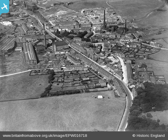
EPW016718 ENGLAND (1926). The town centre, Milnrow, 1926
© Copyright OpenStreetMap contributors and licensed by the OpenStreetMap Foundation. 2026. Cartography is licensed as CC BY-SA.
Nearby Images (2)
EPW016718

EPW016715

Details
| Title | [EPW016718] The town centre, Milnrow, 1926 |
| Reference | EPW016718 |
| Date | 29-August-1926 |
| Link | |
| Place name | MILNROW |
| Parish | |
| District | |
| Country | ENGLAND |
| Easting / Northing | 393148, 412122 |
| Longitude / Latitude | -2.1035647153042, 53.605376487227 |
| National Grid Reference | SD931121 |
Pins

Mel |
Thursday 3rd of June 2021 12:51:22 PM | |
|
Mel |
Thursday 3rd of June 2021 12:47:34 PM | |
|
Mel |
Thursday 3rd of June 2021 12:37:21 PM | |
|
Mel |
Thursday 3rd of June 2021 12:35:03 PM | |
|
josh |
Friday 16th of August 2019 09:42:53 PM | |
|
josh |
Friday 16th of August 2019 09:39:51 PM | |
|
boggy |
Sunday 9th of June 2019 09:02:00 AM | |
|
Rochdales Finest |
Wednesday 26th of October 2016 02:10:42 AM | |
|
Rochdales Finest |
Wednesday 26th of October 2016 02:07:05 AM | |
|
PH2011 |
Sunday 12th of July 2015 11:52:40 AM | |
|
PH2011 |
Sunday 12th of July 2015 11:51:32 AM | |
|
PH2011 |
Sunday 12th of July 2015 11:49:25 AM | |
|
PH2011 |
Sunday 12th of July 2015 11:45:25 AM | |
|
PH2011 |
Sunday 12th of July 2015 11:44:58 AM | |
|
PH2011 |
Sunday 12th of July 2015 11:44:05 AM | |
|
PH2011 |
Sunday 12th of July 2015 11:41:04 AM | |
|
PH2011 |
Sunday 12th of July 2015 11:40:39 AM | |
|
PH2011 |
Sunday 12th of July 2015 11:39:38 AM | |
|
PH2011 |
Sunday 12th of July 2015 11:30:59 AM | |
|
PH2011 |
Sunday 12th of July 2015 11:30:29 AM | |
|
PH2011 |
Sunday 12th of July 2015 11:26:57 AM | |
|
PH2011 |
Sunday 12th of July 2015 11:26:01 AM | |
|
PH2011 |
Sunday 12th of July 2015 11:23:41 AM | |
|
PH2011 |
Sunday 12th of July 2015 11:22:25 AM | |
|
PH2011 |
Sunday 12th of July 2015 11:20:11 AM | |
|
PH2011 |
Sunday 12th of July 2015 11:19:11 AM | |
|
PH2011 |
Sunday 12th of July 2015 11:10:41 AM | |
|
PH2011 |
Sunday 12th of July 2015 11:09:48 AM | |
|
PH2011 |
Sunday 12th of July 2015 11:04:39 AM | |
|
pete |
Sunday 26th of January 2014 08:57:37 PM | |
This isn't the Tim Bobbin, it is Butterworth Hall at the junction of Charles Lane and Water Street. |
PH2011 |
Sunday 12th of July 2015 11:37:51 AM |
|
PH2011 |
Monday 30th of July 2012 10:00:36 PM |