
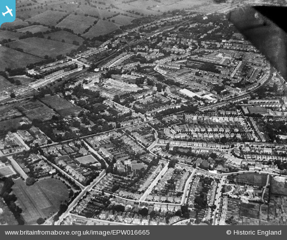
EPW016665 ENGLAND (1926). Ballards Lane and environs, North Finchley, from the south-east, 1926
© Copyright OpenStreetMap contributors and licensed by the OpenStreetMap Foundation. 2025. Cartography is licensed as CC BY-SA.
Nearby Images (2)
EPW016665

EPW016672

Details
| Title | [EPW016665] Ballards Lane and environs, North Finchley, from the south-east, 1926 |
| Reference | EPW016665 |
| Date | August-1926 |
| Link | |
| Place name | NORTH FINCHLEY |
| Parish | |
| District | |
| Country | ENGLAND |
| Easting / Northing | 526113, 191392 |
| Longitude / Latitude | -0.17864092331999, 51.606750908499 |
| National Grid Reference | TQ261914 |
Pins

Danny |
Tuesday 9th of March 2021 12:56:50 PM | |
|
Paul Wendon |
Friday 5th of March 2021 08:31:33 PM | |
|
Paul Wendon |
Friday 5th of March 2021 08:28:03 PM | |
|
haggis |
Thursday 17th of May 2018 09:22:50 AM | |
|
haggis |
Thursday 17th of May 2018 09:22:21 AM | |

melgibbs |
Thursday 24th of April 2014 07:39:46 PM | |
|
melgibbs |
Thursday 24th of April 2014 07:37:38 PM | |
|
melgibbs |
Thursday 24th of April 2014 07:37:09 PM | |
|
mike18 |
Monday 24th of February 2014 01:06:13 PM | |
|
mike18 |
Sunday 19th of January 2014 01:38:50 PM | |
Hi. Actually Spike lived further north along Holden Road and his house would have been built by the time of this photo. I lived around the corner and as kids, we used to try and crawl through the fence at the bottom of his garden to try and catch a glimpse of the great man! He once saw us and yelled from an upstairs window for us to er, kindly leave... |
Drdub |
Monday 2nd of January 2023 05:38:43 PM |
|
mike18 |
Sunday 19th of January 2014 01:35:30 PM | |
|
mike18 |
Sunday 19th of January 2014 01:34:33 PM | |
|
David Morris |
Monday 7th of January 2013 11:37:26 AM |