
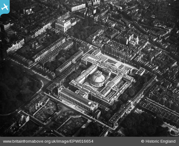
EPW016654 ENGLAND (1926). The British Museum, Bloomsbury, 1926. This image has been produced from a print.
© Copyright OpenStreetMap contributors and licensed by the OpenStreetMap Foundation. 2026. Cartography is licensed as CC BY-SA.
Nearby Images (22)
EPW016654

EPW006680

EPW039568

EAW041950

EPW039567

EPW019025

EPW008741

EPW005920

EPW016653

EPW024279

EPW020959

EPW020960

EAW030117

EAW041945

EPW060553

EPW060556

EAW041944

EPW060557

EPW060555

EAW000479

EPW060554

EAW000478

Details
| Title | [EPW016654] The British Museum, Bloomsbury, 1926. This image has been produced from a print. |
| Reference | EPW016654 |
| Date | August-1926 |
| Link | |
| Place name | BLOOMSBURY |
| Parish | |
| District | |
| Country | ENGLAND |
| Easting / Northing | 530099, 181742 |
| Longitude / Latitude | -0.12467900577753, 51.519113773804 |
| National Grid Reference | TQ301817 |
Pins
Be the first to add a comment to this image!
User Comment Contributions
The British Museum |

Alan McFaden |
Friday 14th of November 2014 02:11:39 PM |

The British Museum |
Alan McFaden |
Friday 14th of November 2014 02:11:19 PM |
The British Museum |
Alan McFaden |
Friday 14th of November 2014 02:10:57 PM |