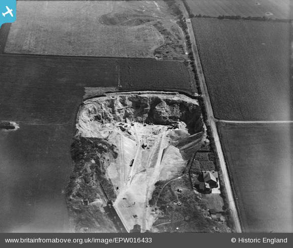
EPW016433 ENGLAND (1926). Ford Quarry, South Hylton, 1926
    © Copyright OpenStreetMap contributors and licensed by the OpenStreetMap Foundation. 2025. Cartography is licensed as CC BY-SA.
  
Nearby Images (5)
Details
| Title | [EPW016433] Ford Quarry, South Hylton, 1926 | 
| Reference | EPW016433 | 
| Date | 29-July-1926 | 
| Link | |
| Place name | SOUTH HYLTON | 
| Parish | |
| District | |
| Country | ENGLAND | 
| Easting / Northing | 436163, 557010 | 
| Longitude / Latitude | -1.4359295679066, 54.906412967541 | 
| National Grid Reference | NZ362570 | 
 
             
  ![[EPW016433] Ford Quarry, South Hylton, 1926](http://britainfromabove.org.uk/sites/all/libraries/aerofilms-images/public/100x100/EPW/016/EPW016433.jpg) 
  
                                          ![[EPW016435] Ford Quarry, South Hylton, 1926](http://britainfromabove.org.uk/sites/all/libraries/aerofilms-images/public/100x100/EPW/016/EPW016435.jpg) 
 ![[EPW016436] Ford Quarry, South Hylton, 1926](http://britainfromabove.org.uk/sites/all/libraries/aerofilms-images/public/100x100/EPW/016/EPW016436.jpg) 
 ![[EPW016432] Ford Quarry, South Hylton, 1926](http://britainfromabove.org.uk/sites/all/libraries/aerofilms-images/public/100x100/EPW/016/EPW016432.jpg) 
 ![[EPW016434] Ford Quarry and the Ford Paper Mills, South Hylton, 1926](http://britainfromabove.org.uk/sites/all/libraries/aerofilms-images/public/100x100/EPW/016/EPW016434.jpg) 
  Narrow-gauge quarry track. Easily re-laid as quarry develops
 Narrow-gauge quarry track. Easily re-laid as quarry develops