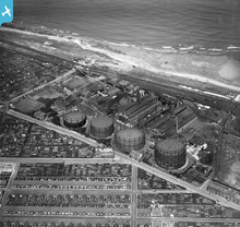
EPW016368 ENGLAND (1926). The Gas Works at Hendon, Sunderland, 1926
© Copyright OpenStreetMap contributors and licensed by the OpenStreetMap Foundation. 2026. Cartography is licensed as CC BY-SA.
Nearby Images (9)
Details
| Title | [EPW016368] The Gas Works at Hendon, Sunderland, 1926 |
| Reference | EPW016368 |
| Date | 29-July-1926 |
| Link | |
| Place name | SUNDERLAND |
| Parish | |
| District | |
| Country | ENGLAND |
| Easting / Northing | 440867, 555505 |
| Longitude / Latitude | -1.3627749406094, 54.892525128446 |
| National Grid Reference | NZ409555 |
Pins

MalcolmGH |
Friday 19th of October 2012 05:10:25 PM |
User Comment Contributions

Alison Cutforth |
Wednesday 13th of March 2013 03:53:45 PM | |
The large building with a gable at the left hand side in the center of the photograph is The Blue House pub; its still standing and the allotments to the left of it are still there. I had not realized just how extensive these allotments once were-the top left shows another large area of them which were later built on by industrial buildings. The allotments opposite the pub, towards the bottom of the photo, were built on with council houses(Corporation Road). I grew up in the terrace of single story cottages in the center of the picture (Canon Cockin Street)in the 1950s and early 1960's. The single story design of terrace was a particular feature of Sunderland's housing. At the right hand end of the terrace you can identify six cottages with dormer windows. Those six cottages still have those dormers although they are obviously replacements. When the wind was from the east off the north sea (to the top of the photo) it carried the smell of gas works to the houses and it was not a good idea to hang out washing on those days. When the wind was from the south east you got the smoke from the paper mills instead. |

NickT |
Tuesday 26th of June 2012 09:46:10 PM |


![[EPW016368] The Gas Works at Hendon, Sunderland, 1926](http://britainfromabove.org.uk/sites/all/libraries/aerofilms-images/public/100x100/EPW/016/EPW016368.jpg)
![[EPW016364] The Gas Works at Hendon, Sunderland, 1926](http://britainfromabove.org.uk/sites/all/libraries/aerofilms-images/public/100x100/EPW/016/EPW016364.jpg)
![[EPW016367] The Gas Works at Hendon, Sunderland, 1926](http://britainfromabove.org.uk/sites/all/libraries/aerofilms-images/public/100x100/EPW/016/EPW016367.jpg)
![[EPW016370] The Gas Works at Hendon, Sunderland, 1926](http://britainfromabove.org.uk/sites/all/libraries/aerofilms-images/public/100x100/EPW/016/EPW016370.jpg)
![[EPW016363] The Gas Works at Hendon, Sunderland, 1926](http://britainfromabove.org.uk/sites/all/libraries/aerofilms-images/public/100x100/EPW/016/EPW016363.jpg)
![[EPW016365] The Gas Works at Hendon, Sunderland, 1926](http://britainfromabove.org.uk/sites/all/libraries/aerofilms-images/public/100x100/EPW/016/EPW016365.jpg)
![[EPW016366] The Gas Works at Hendon, Sunderland, 1926](http://britainfromabove.org.uk/sites/all/libraries/aerofilms-images/public/100x100/EPW/016/EPW016366.jpg)
![[EPW016362] The Gas Works at Hendon, Sunderland, 1926](http://britainfromabove.org.uk/sites/all/libraries/aerofilms-images/public/100x100/EPW/016/EPW016362.jpg)
![[EPW016369] The Gas Works at Hendon, Sunderland, 1926](http://britainfromabove.org.uk/sites/all/libraries/aerofilms-images/public/100x100/EPW/016/EPW016369.jpg)
