
EPW015984 ENGLAND (1926). Crossmead and environs, Oxhey, 1926
© Copyright OpenStreetMap contributors and licensed by the OpenStreetMap Foundation. 2026. Cartography is licensed as CC BY-SA.
Nearby Images (2)
EPW015984

EPW040467

Details
| Title | [EPW015984] Crossmead and environs, Oxhey, 1926 |
| Reference | EPW015984 |
| Date | 30-June-1926 |
| Link | |
| Place name | OXHEY |
| Parish | |
| District | |
| Country | ENGLAND |
| Easting / Northing | 510862, 195091 |
| Longitude / Latitude | -0.39762994925643, 51.64321043936 |
| National Grid Reference | TQ109951 |
Pins
 |

Bluid |
Wednesday 9th of January 2019 09:38:50 PM |
|
Bluid |
Wednesday 9th of January 2019 09:34:55 PM | |
|
Bluid |
Tuesday 17th of June 2014 12:06:14 PM | |
|
Bluid |
Monday 24th of March 2014 09:50:50 PM | |
|
Bluid |
Saturday 6th of April 2013 08:32:55 PM | |
|
Bluid |
Saturday 6th of April 2013 07:05:40 PM | |
|
Bluid |
Saturday 6th of April 2013 07:03:00 PM | |
|
Bluid |
Saturday 6th of April 2013 06:57:10 PM | |

John Swain |
Tuesday 10th of July 2012 04:48:01 PM | |
|
John Swain |
Tuesday 10th of July 2012 04:45:00 PM | |
|
John Swain |
Tuesday 10th of July 2012 04:43:59 PM | |
|
John Swain |
Tuesday 10th of July 2012 04:43:19 PM | |
|
John Swain |
Tuesday 10th of July 2012 04:42:37 PM | |
|
John Swain |
Tuesday 10th of July 2012 04:41:30 PM |


User Comment Contributions

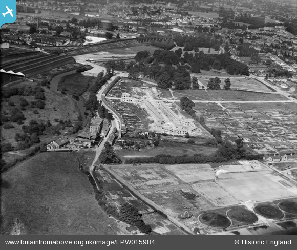
An interesting photo of the southern margins of Watford and the varied land uses in the Colne valley near Oxhey. |
John Swain |
Saturday 3rd of August 2013 10:11:39 AM |
|
Top right of this pic is Bushey Manor. A health centre sits in its place now |
Bluid |
Sunday 7th of April 2013 09:07:54 AM |
|
Top right of this pic is Bushey Manor. A health centre sits in its place now |
Bluid |
Sunday 7th of April 2013 09:04:01 AM |
The Rookery Silk Mill was situated on the river Colne, where a set of sluices controlled the flow of water into the works. At its peak in the late 18th century, the mill was three storeys high and employed 100 people, a major manufactory of the Watford area. In 1881, the mill closed and was replaced by the Watford Steam Laundry & Dye Works, as shown on the 1898 Ordnance Survey Map. The buildings were later converted into a factory producing pianos and eventually were reported as being workshops and offices for engineers and joiners in the early 1970s. |
John Swain |
Wednesday 11th of July 2012 08:15:51 AM |
A rare view of the southern extremity of Watford during the interwar period. In the right foreground are the settling tanks and filter beds of the Bushey UDC Sewage Works, beyond which is Riverside Road (1920 terraces) and the former silk mill on the banks of the river Colne.In the centre of picture, the new housing and streets of Crossmead and Colne Avenue are readily apparent, whereas to the left (north) are the 1915 LNWR Carriage Sheds at Croxley Green Junction. In the distance, is the 1912 viaduct carrying the LMS Croxley Green and Bushey Curves over the river Colne. Note: after the Railway Act of 1921, the London & North-Western Railway (LNWR) became the London Midland & Scottish Railway (LMS) as part of the "Big Four" Grouping on January 1st, 1923. |
John Swain |
Tuesday 10th of July 2012 04:39:09 PM |