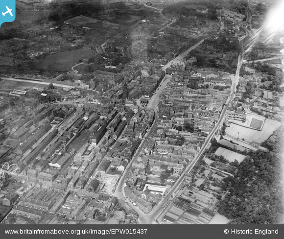
EPW015437 ENGLAND (1926). Ropergate, the Market Place and surroundings, Pontefract, 1926
© Copyright OpenStreetMap contributors and licensed by the OpenStreetMap Foundation. 2026. Cartography is licensed as CC BY-SA.
Nearby Images (5)
Details
| Title | [EPW015437] Ropergate, the Market Place and surroundings, Pontefract, 1926 |
| Reference | EPW015437 |
| Date | 4-May-1926 |
| Link | |
| Place name | PONTEFRACT |
| Parish | |
| District | |
| Country | ENGLAND |
| Easting / Northing | 445525, 421833 |
| Longitude / Latitude | -1.310515535372, 53.690731532981 |
| National Grid Reference | SE455218 |
Pins

dyey |
Wednesday 30th of December 2015 10:49:25 PM | |

Derekdye |
Monday 14th of January 2013 09:03:47 PM | |

Derekdye |
Monday 14th of January 2013 08:54:34 PM | |

Derekdye |
Monday 14th of January 2013 08:53:30 PM | |

Class31 |
Friday 26th of October 2012 04:35:12 PM | |

Class31 |
Friday 26th of October 2012 04:34:19 PM | |

Class31 |
Friday 26th of October 2012 04:33:46 PM | |

Class31 |
Friday 26th of October 2012 04:32:57 PM | |

Class31 |
Friday 26th of October 2012 04:32:34 PM | |

Class31 |
Friday 26th of October 2012 04:32:14 PM | |

Class31 |
Friday 26th of October 2012 04:31:32 PM | |

pjay |
Saturday 20th of October 2012 02:29:27 PM | |

pjay |
Saturday 20th of October 2012 02:27:53 PM |


![[EPW015437] Ropergate, the Market Place and surroundings, Pontefract, 1926](http://britainfromabove.org.uk/sites/all/libraries/aerofilms-images/public/100x100/EPW/015/EPW015437.jpg)
![[EPW015440] St Giles's Church and the Market Place, Pontefract, 1926](http://britainfromabove.org.uk/sites/all/libraries/aerofilms-images/public/100x100/EPW/015/EPW015440.jpg)
![[EPW015438] St Giles's Church and the Market Place, Pontefract, 1926](http://britainfromabove.org.uk/sites/all/libraries/aerofilms-images/public/100x100/EPW/015/EPW015438.jpg)
![[EPW034159] The Corn Market, Market Place and town centre, Pontefract, 1930](http://britainfromabove.org.uk/sites/all/libraries/aerofilms-images/public/100x100/EPW/034/EPW034159.jpg)
![[EPW015439] Newgate and Crab Hill, Pontefract, 1926](http://britainfromabove.org.uk/sites/all/libraries/aerofilms-images/public/100x100/EPW/015/EPW015439.jpg)