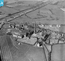
EPW015107 ENGLAND (1926). The Churchbridge Edge Tool and Axle Works, Churchbridge, 1926
© Copyright OpenStreetMap contributors and licensed by the OpenStreetMap Foundation. 2026. Cartography is licensed as CC BY-SA.
Details
| Title | [EPW015107] The Churchbridge Edge Tool and Axle Works, Churchbridge, 1926 |
| Reference | EPW015107 |
| Date | 12-April-1926 |
| Link | |
| Place name | CHURCHBRIDGE |
| Parish | GREAT WYRLEY |
| District | |
| Country | ENGLAND |
| Easting / Northing | 398606, 308145 |
| Longitude / Latitude | -2.0206172147346, 52.67066534158 |
| National Grid Reference | SJ986081 |
Pins

areed |
Wednesday 23rd of December 2020 12:22:47 PM | |

areed |
Wednesday 23rd of December 2020 12:21:40 PM | |

areed |
Wednesday 23rd of December 2020 12:20:45 PM | |

areed |
Wednesday 23rd of December 2020 12:20:25 PM | |

areed |
Wednesday 23rd of December 2020 12:19:59 PM | |

areed |
Wednesday 23rd of December 2020 12:17:17 PM | |

areed |
Friday 24th of April 2020 08:14:04 PM | |

Andrew |
Saturday 20th of February 2016 11:54:04 AM | |

Andrew |
Saturday 20th of February 2016 11:49:28 AM | |

curnock |
Tuesday 5th of February 2013 01:37:30 PM | |

curnock |
Tuesday 5th of February 2013 01:35:16 PM | |

Martin |
Saturday 13th of October 2012 06:22:41 PM | |

Martin |
Saturday 30th of June 2012 10:23:53 PM | |

Martin |
Saturday 30th of June 2012 08:04:28 PM |
User Comment Contributions

Martin |
Friday 6th of July 2012 05:52:31 PM |


