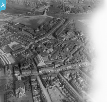
EPW015055 ENGLAND (1926). St Peter's Church and environs, Walsall, 1926
© Copyright OpenStreetMap contributors and licensed by the OpenStreetMap Foundation. 2026. Cartography is licensed as CC BY-SA.
Details
| Title | [EPW015055] St Peter's Church and environs, Walsall, 1926 |
| Reference | EPW015055 |
| Date | 12-April-1926 |
| Link | |
| Place name | WALSALL |
| Parish | |
| District | |
| Country | ENGLAND |
| Easting / Northing | 401153, 299317 |
| Longitude / Latitude | -1.9829779951719, 52.591295324871 |
| National Grid Reference | SP012993 |
Pins

Sandwell Street Kid |
Tuesday 18th of March 2014 08:43:44 PM | |

Sandwell Street Kid |
Tuesday 18th of March 2014 08:32:53 PM | |

Sandwell Street Kid |
Thursday 13th of March 2014 04:30:49 PM | |

Sandwell Street Kid |
Thursday 13th of March 2014 04:15:48 PM | |

Sandwell Street Kid |
Thursday 13th of March 2014 03:14:32 PM | |

Sandwell Street Kid |
Thursday 13th of March 2014 03:11:53 PM | |

Sandwell Street Kid |
Thursday 13th of March 2014 03:10:32 PM | |

Sandwell Street Kid |
Thursday 13th of March 2014 03:09:47 PM | |

Sandwell Street Kid |
Thursday 13th of March 2014 03:08:56 PM | |

Sandwell Street Kid |
Thursday 13th of March 2014 03:08:29 PM | |

Sandwell Street Kid |
Thursday 13th of March 2014 03:07:14 PM | |

Sandwell Street Kid |
Thursday 13th of March 2014 03:06:00 PM | |

Sandwell Street Kid |
Thursday 13th of March 2014 03:05:29 PM | |

Sandwell Street Kid |
Thursday 13th of March 2014 03:04:39 PM | |

Sandwell Street Kid |
Thursday 13th of March 2014 03:03:47 PM | |

Sandwell Street Kid |
Thursday 13th of March 2014 03:02:55 PM | |

Sandwell Street Kid |
Thursday 13th of March 2014 03:02:20 PM | |

Sandwell Street Kid |
Thursday 13th of March 2014 03:00:26 PM | |

Sandwell Street Kid |
Thursday 13th of March 2014 02:51:14 PM | |

KevTheBusDriver |
Sunday 2nd of February 2014 09:23:31 PM | |

KevTheBusDriver |
Sunday 2nd of February 2014 09:22:04 PM |
User Comment Contributions
Can see lots of washing on hanging on lines, just checked and 12th April 1926 was a Monday, hence the washing. |

Sandwell Street Kid |
Thursday 13th of March 2014 03:56:54 PM |
A good drying day is a good flying day! I love seeing the laundry in Aerofilms images, it's everywhere. Especially in the "back-to-back" streets where the laundry hangs across the streets from the front of one house to another; this really gets across the nature of that style of housing. Katy |
Katy Whitaker |
Thursday 13th of March 2014 03:56:54 PM |

Sandwell Street Kid |
Thursday 13th of March 2014 02:50:10 PM |


![[EPW015055] St Peter's Church and environs, Walsall, 1926](http://britainfromabove.org.uk/sites/all/libraries/aerofilms-images/public/100x100/EPW/015/EPW015055.jpg)
![[EAW000784] The area between Stafford Street, Whitehouse Street and Green Lane, Birchills, 1946](http://britainfromabove.org.uk/sites/all/libraries/aerofilms-images/public/100x100/EAW/000/EAW000784.jpg)
![[EAW000783] Long Acre Street, Whitehouse Street, the Wheway & Son Ltd Birchills Hame & Chain Works and environs, Birchills, 1946](http://britainfromabove.org.uk/sites/all/libraries/aerofilms-images/public/100x100/EAW/000/EAW000783.jpg)
