
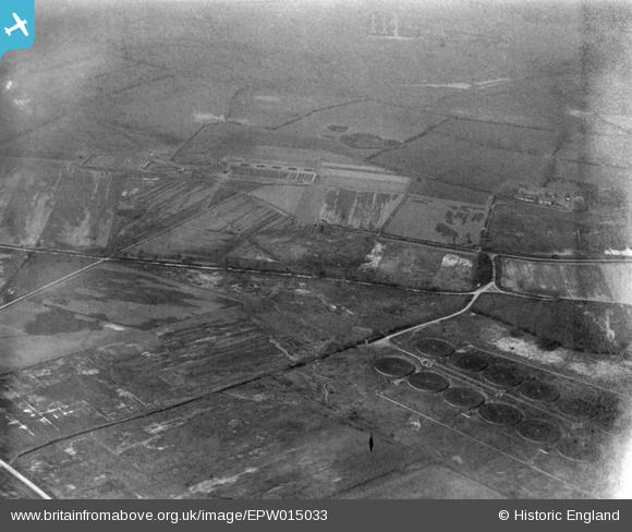
EPW015033 ENGLAND (1926). Rowley Lane and environs, Baginton, 1926
© Copyright OpenStreetMap contributors and licensed by the OpenStreetMap Foundation. 2026. Cartography is licensed as CC BY-SA.
Nearby Images (7)
EPW015033

EPW015014

EPW015020

EPW015016

EPW015017

EPW015032

EPW015013

Details
| Title | [EPW015033] Rowley Lane and environs, Baginton, 1926 |
| Reference | EPW015033 |
| Date | 12-April-1926 |
| Link | |
| Place name | BAGINTON |
| Parish | BAGINTON |
| District | |
| Country | ENGLAND |
| Easting / Northing | 435585, 274945 |
| Longitude / Latitude | -1.4772659937491, 52.371011843723 |
| National Grid Reference | SP356749 |
Pins

Class31 |
Tuesday 31st of July 2012 02:21:31 PM |
User Comment Contributions
It's the same location as image EPW015014 which is titled "Coventry Corporation Sewage Farm, Baginton, 1926". |

Jason |
Tuesday 23rd of October 2012 03:19:32 PM |
Thanks for spotting this one Jason. We can update the catalogue and the revised record with the correct location will appear here in due course. Yours, Katy Britain from Above Cataloguing Team Leader |
Katy Whitaker |
Tuesday 23rd of October 2012 03:19:32 PM |
Baginton Sewage works in foreground, Baginton airfield, later Coventry Airport to the left and back. |
Mark C |
Wednesday 4th of July 2012 07:32:00 PM |
Just a stab. Would this be Minworth? |
K S Clark |
Friday 29th of June 2012 10:35:37 PM |
Water or Sewage Treatment Farm ? |
BigglesH |
Tuesday 26th of June 2012 04:03:02 PM |