
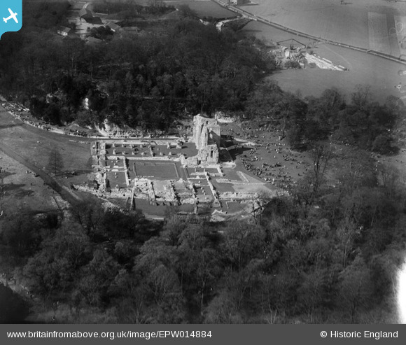
EPW014884 ENGLAND (1926). The ruins of Roche Abbey, Roche Abbey, 1926
© Copyright OpenStreetMap contributors and licensed by the OpenStreetMap Foundation. 2026. Cartography is licensed as CC BY-SA.
Nearby Images (7)
EPW014884

EPW014885

EPW014882

EAW003573

EPW014883

EAW003575

EAW003574

Details
| Title | [EPW014884] The ruins of Roche Abbey, Roche Abbey, 1926 |
| Reference | EPW014884 |
| Date | 29-May-1926 |
| Link | |
| Place name | ROCHE ABBEY |
| Parish | MALTBY |
| District | |
| Country | ENGLAND |
| Easting / Northing | 454403, 389821 |
| Longitude / Latitude | -1.1816401755447, 53.402143365555 |
| National Grid Reference | SK544898 |
Pins

Maurice |
Friday 25th of January 2013 07:09:51 AM |
User Comment Contributions
View looking north. Beautifully set in a valley landscaped by ‘Capability’ Brown in the 18th Century. Roche Abbey has one of the most complete ground plans of any English Cistercian monastery, laid out as excavated foundations. Why is the location so popular on this day? There must be something on. |

Class31 |
Thursday 24th of January 2013 07:56:22 AM |
The 29th May 1926 was a Saturday. Easter that year was 4th April so this being the 7th weekend after that makes it the Whitsun weekend. |
Maurice |
Thursday 24th of January 2013 07:56:22 AM |