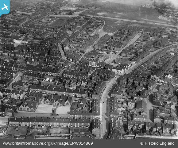
EPW014869 ENGLAND (1926). Broad Street and environs, Rawmarsh, 1926
© Copyright OpenStreetMap contributors and licensed by the OpenStreetMap Foundation. 2026. Cartography is licensed as CC BY-SA.
Details
| Title | [EPW014869] Broad Street and environs, Rawmarsh, 1926 |
| Reference | EPW014869 |
| Date | April-1926 |
| Link | |
| Place name | RAWMARSH |
| Parish | |
| District | |
| Country | ENGLAND |
| Easting / Northing | 443662, 395346 |
| Longitude / Latitude | -1.3424331007197, 53.452805383447 |
| National Grid Reference | SK437953 |
Pins

martingreen13 |
Sunday 22nd of January 2023 05:23:31 PM | |

ChrisB |
Monday 4th of January 2021 12:30:19 PM | |

Views In Camera |
Friday 29th of May 2020 08:10:27 PM | |

beaufighter |
Thursday 12th of October 2017 07:05:50 PM | |

Class31 |
Wednesday 23rd of January 2013 09:42:15 PM | |

Class31 |
Wednesday 23rd of January 2013 09:40:44 PM | |

Class31 |
Wednesday 23rd of January 2013 09:39:09 PM | |

Class31 |
Wednesday 23rd of January 2013 09:38:09 PM | |

Scott |
Sunday 8th of July 2012 10:54:14 AM | |

Scott |
Sunday 8th of July 2012 10:51:28 AM |


![[EPW014869] Broad Street and environs, Rawmarsh, 1926](http://britainfromabove.org.uk/sites/all/libraries/aerofilms-images/public/100x100/EPW/014/EPW014869.jpg)
![[EPW014874] Bear Tree Road and environs, Rawmarsh, 1926](http://britainfromabove.org.uk/sites/all/libraries/aerofilms-images/public/100x100/EPW/014/EPW014874.jpg)