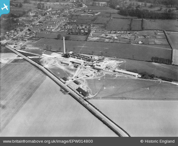
EPW014800 ENGLAND (1926). The Associated Portland Cement Works, Houghton Regis, 1926
© Copyright OpenStreetMap contributors and licensed by the OpenStreetMap Foundation. 2026. Cartography is licensed as CC BY-SA.
Nearby Images (16)
Details
| Title | [EPW014800] The Associated Portland Cement Works, Houghton Regis, 1926 |
| Reference | EPW014800 |
| Date | 24-March-1926 |
| Link | |
| Place name | HOUGHTON REGIS |
| Parish | HOUGHTON REGIS |
| District | |
| Country | ENGLAND |
| Easting / Northing | 501551, 223278 |
| Longitude / Latitude | -0.52391474435588, 51.898345666593 |
| National Grid Reference | TL016233 |
Pins

Dylan Moore |
Thursday 16th of March 2017 11:51:49 AM | |

Dylan Moore |
Thursday 16th of March 2017 11:48:18 AM | |

Dylan Moore |
Thursday 16th of March 2017 11:42:40 AM | |

Dylan Moore |
Thursday 16th of March 2017 11:39:10 AM | |

Dylan Moore |
Thursday 16th of March 2017 11:38:47 AM | |

Dylan Moore |
Thursday 16th of March 2017 11:36:22 AM | |

Dylan Moore |
Thursday 16th of March 2017 11:35:52 AM | |

Dylan Moore |
Thursday 16th of March 2017 11:33:43 AM | |

Dylan Moore |
Thursday 16th of March 2017 11:32:50 AM | |

Dylan Moore |
Thursday 16th of March 2017 11:32:14 AM | |

Dylan Moore |
Thursday 16th of March 2017 11:29:45 AM | |

Dylan Moore |
Thursday 16th of March 2017 11:29:24 AM | |

Dylan Moore |
Thursday 16th of March 2017 11:28:10 AM | |

Dylan Moore |
Thursday 16th of March 2017 11:27:32 AM | |

Jim |
Tuesday 25th of August 2015 03:00:23 PM | |

Jim |
Tuesday 25th of August 2015 02:46:58 PM | |

zebra99 |
Tuesday 3rd of December 2013 09:41:39 AM | |
This was the location of the kennels for the hunt. Colonel Part was master of the hunt. |

Jim |
Tuesday 25th of August 2015 03:02:14 PM |

Dylan Moore |
Thursday 18th of October 2012 03:52:19 PM | |

Dylan Moore |
Thursday 18th of October 2012 03:51:39 PM | |

Dylan Moore |
Thursday 18th of October 2012 03:51:07 PM | |

Dylan Moore |
Thursday 18th of October 2012 03:50:34 PM | |

John HT |
Friday 6th of July 2012 05:38:37 PM | |

Class31 |
Wednesday 4th of July 2012 01:56:38 PM | |

Class31 |
Wednesday 4th of July 2012 01:56:16 PM | |

Class31 |
Wednesday 4th of July 2012 01:55:52 PM |
User Comment Contributions

Dylan Moore |
Thursday 18th of October 2012 03:57:32 PM | |

The Dunstable cement plant began operation in 1926 under the ownership of the Dunstable Portland Cement Company. It was acquired by the Red Triangle Group shortly after this picture was taken, in late 1927. After the collapse of Red Triangle in 1931, it was acquired by APCM. A third kiln was installed in 1937 and a fourth in 1966. It shut down in 1971. Here the plant is under construction. Two kilns, two clinker coolers and two cement mills can be clearly seen. The slurry pipeline from the quarry has been laid in a trench under the road, and its course is visible. |

Dylan Moore |
Thursday 18th of October 2012 03:56:30 PM |


![[EPW014800] The Associated Portland Cement Works, Houghton Regis, 1926](http://britainfromabove.org.uk/sites/all/libraries/aerofilms-images/public/100x100/EPW/014/EPW014800.jpg)
![[EPW019207] The Associated Portland Cement Works and environs, Houghton Regis, 1927](http://britainfromabove.org.uk/sites/all/libraries/aerofilms-images/public/100x100/EPW/019/EPW019207.jpg)
![[EPW019202] The Associated Portland Cement Works and environs, Houghton Regis, 1927](http://britainfromabove.org.uk/sites/all/libraries/aerofilms-images/public/100x100/EPW/019/EPW019202.jpg)
![[EPW014801] The Associated Portland Cement Works, Houghton Regis, 1926](http://britainfromabove.org.uk/sites/all/libraries/aerofilms-images/public/100x100/EPW/014/EPW014801.jpg)
![[EPW019211] The Associated Portland Cement Works, Houghton Regis, 1927](http://britainfromabove.org.uk/sites/all/libraries/aerofilms-images/public/100x100/EPW/019/EPW019211.jpg)
![[EPW019210] The Associated Portland Cement Works, Houghton Regis, 1927](http://britainfromabove.org.uk/sites/all/libraries/aerofilms-images/public/100x100/EPW/019/EPW019210.jpg)
![[EPW019215] The Associated Portland Cement Works, Houghton Regis, 1927](http://britainfromabove.org.uk/sites/all/libraries/aerofilms-images/public/100x100/EPW/019/EPW019215.jpg)
![[EPW019209] The Associated Portland Cement Works and environs, Houghton Regis, 1927](http://britainfromabove.org.uk/sites/all/libraries/aerofilms-images/public/100x100/EPW/019/EPW019209.jpg)
![[EPW019212] The Associated Portland Cement Works, Houghton Regis, 1927](http://britainfromabove.org.uk/sites/all/libraries/aerofilms-images/public/100x100/EPW/019/EPW019212.jpg)
![[EPW019208] The Associated Portland Cement Works and environs, Houghton Regis, 1927](http://britainfromabove.org.uk/sites/all/libraries/aerofilms-images/public/100x100/EPW/019/EPW019208.jpg)
![[EPW019205] The Associated Portland Cement Works and environs, Houghton Regis, 1927](http://britainfromabove.org.uk/sites/all/libraries/aerofilms-images/public/100x100/EPW/019/EPW019205.jpg)
![[EPW019204] The Associated Portland Cement Works, Houghton Regis, 1927](http://britainfromabove.org.uk/sites/all/libraries/aerofilms-images/public/100x100/EPW/019/EPW019204.jpg)
![[EPW019203] The Associated Portland Cement Works, Houghton Regis, 1927](http://britainfromabove.org.uk/sites/all/libraries/aerofilms-images/public/100x100/EPW/019/EPW019203.jpg)
![[EPW019201] The Associated Portland Cement Works, Houghton Regis, 1927](http://britainfromabove.org.uk/sites/all/libraries/aerofilms-images/public/100x100/EPW/019/EPW019201.jpg)
![[EPW019213] The Associated Portland Cement Works, Houghton Regis, 1927](http://britainfromabove.org.uk/sites/all/libraries/aerofilms-images/public/100x100/EPW/019/EPW019213.jpg)
![[EPW019206] The Associated Portland Cement Works and environs, Houghton Regis, 1927](http://britainfromabove.org.uk/sites/all/libraries/aerofilms-images/public/100x100/EPW/019/EPW019206.jpg)
