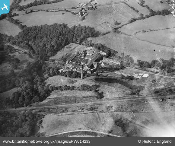
EPW014233 ENGLAND (1925). Waterside Paper Mill and adjacent sewage works, Disley, 1925
© Copyright OpenStreetMap contributors and licensed by the OpenStreetMap Foundation. 2026. Cartography is licensed as CC BY-SA.
Nearby Images (12)
Details
| Title | [EPW014233] Waterside Paper Mill and adjacent sewage works, Disley, 1925 |
| Reference | EPW014233 |
| Date | 27-August-1925 |
| Link | |
| Place name | DISLEY |
| Parish | DISLEY |
| District | |
| Country | ENGLAND |
| Easting / Northing | 398045, 385312 |
| Longitude / Latitude | -2.0293819077933, 53.364409603811 |
| National Grid Reference | SJ980853 |
Pins

thecoiledsponge |
Tuesday 17th of April 2018 12:24:10 PM |


![[EPW014233] Waterside Paper Mill and adjacent sewage works, Disley, 1925](http://britainfromabove.org.uk/sites/all/libraries/aerofilms-images/public/100x100/EPW/014/EPW014233.jpg)
![[EAW001588] The Waterside Paper Mill painted in camouflage, Disley, 1946](http://britainfromabove.org.uk/sites/all/libraries/aerofilms-images/public/100x100/EAW/001/EAW001588.jpg)
![[EPW014231] Waterside Paper Mill and adjacent sewage works, Disley, 1925](http://britainfromabove.org.uk/sites/all/libraries/aerofilms-images/public/100x100/EPW/014/EPW014231.jpg)
![[EAW001586] The Waterside Paper Mill painted in camouflage, Disley, 1946](http://britainfromabove.org.uk/sites/all/libraries/aerofilms-images/public/100x100/EAW/001/EAW001586.jpg)
![[EAW001583] The Waterside Paper Mill painted in camouflage, Disley, 1946](http://britainfromabove.org.uk/sites/all/libraries/aerofilms-images/public/100x100/EAW/001/EAW001583.jpg)
![[EPW014232] Waterside Paper Mill, adjacent sewage works and environs, Disley, 1925](http://britainfromabove.org.uk/sites/all/libraries/aerofilms-images/public/100x100/EPW/014/EPW014232.jpg)
![[EAW001582] The Waterside Paper Mill painted in camouflage, Disley, 1946](http://britainfromabove.org.uk/sites/all/libraries/aerofilms-images/public/100x100/EAW/001/EAW001582.jpg)
![[EPW014230] Waterside Paper Mill and adjacent sewage works, Disley, 1925](http://britainfromabove.org.uk/sites/all/libraries/aerofilms-images/public/100x100/EPW/014/EPW014230.jpg)
![[EAW001585] The Waterside Paper Mill painted in camouflage, Disley, 1946](http://britainfromabove.org.uk/sites/all/libraries/aerofilms-images/public/100x100/EAW/001/EAW001585.jpg)
![[EAW001584] The Waterside Paper Mill painted in camouflage, Disley, 1946](http://britainfromabove.org.uk/sites/all/libraries/aerofilms-images/public/100x100/EAW/001/EAW001584.jpg)
![[EAW001587] The Waterside Paper Mill painted in camouflage, Disley, 1946](http://britainfromabove.org.uk/sites/all/libraries/aerofilms-images/public/100x100/EAW/001/EAW001587.jpg)
![[EAW001581] The Waterside Paper Mill painted in camouflage, Disley, 1946](http://britainfromabove.org.uk/sites/all/libraries/aerofilms-images/public/100x100/EAW/001/EAW001581.jpg)