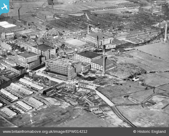
EPW014212 ENGLAND (1925). Hall Lane Cotton Spinning Mill and environs, Leigh, 1925. This image has been produced from a copy-negative.
© Copyright OpenStreetMap contributors and licensed by the OpenStreetMap Foundation. 2026. Cartography is licensed as CC BY-SA.
Details
| Title | [EPW014212] Hall Lane Cotton Spinning Mill and environs, Leigh, 1925. This image has been produced from a copy-negative. |
| Reference | EPW014212 |
| Date | 27-August-1925 |
| Link | |
| Place name | LEIGH |
| Parish | |
| District | |
| Country | ENGLAND |
| Easting / Northing | 366340, 399597 |
| Longitude / Latitude | -2.5073958679971, 53.491752305944 |
| National Grid Reference | SJ663996 |
Pins

jennyB |
Wednesday 4th of March 2015 10:00:36 PM | |

jennyB |
Wednesday 4th of March 2015 09:57:58 PM | |

jennyB |
Wednesday 4th of March 2015 09:55:50 PM | |

jennyB |
Wednesday 4th of March 2015 09:54:41 PM | |

jennyB |
Wednesday 4th of March 2015 09:54:36 PM |


![[EPW014212] Hall Lane Cotton Spinning Mill and environs, Leigh, 1925. This image has been produced from a copy-negative.](http://britainfromabove.org.uk/sites/all/libraries/aerofilms-images/public/100x100/EPW/014/EPW014212.jpg)
![[EPW031117] Hall Lane and Mather Lane Cotton Spinning Mills, Leigh, 1929](http://britainfromabove.org.uk/sites/all/libraries/aerofilms-images/public/100x100/EPW/031/EPW031117.jpg)