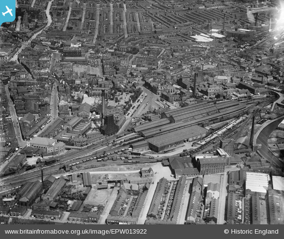
EPW013922 ENGLAND (1925). The station and environs, Blackburn, 1925
© Copyright OpenStreetMap contributors and licensed by the OpenStreetMap Foundation. 2026. Cartography is licensed as CC BY-SA.
Nearby Images (13)
Details
| Title | [EPW013922] The station and environs, Blackburn, 1925 |
| Reference | EPW013922 |
| Date | August-1925 |
| Link | |
| Place name | BLACKBURN |
| Parish | |
| District | |
| Country | ENGLAND |
| Easting / Northing | 368433, 427894 |
| Longitude / Latitude | -2.4787161550891, 53.746242953066 |
| National Grid Reference | SD684279 |
Pins

stewpot |
Monday 30th of December 2019 06:07:54 PM | |

powerpop |
Saturday 7th of July 2018 07:56:09 PM | |

powerpop |
Saturday 7th of July 2018 07:55:02 PM | |

powerpop |
Saturday 7th of July 2018 07:54:09 PM | |

powerpop |
Saturday 7th of July 2018 07:53:19 PM | |

powerpop |
Saturday 7th of July 2018 07:52:37 PM | |

powerpop |
Saturday 7th of July 2018 07:51:23 PM | |

powerpop |
Saturday 7th of July 2018 07:50:42 PM | |

powerpop |
Saturday 7th of July 2018 07:49:58 PM | |

powerpop |
Saturday 7th of July 2018 07:49:27 PM | |

powerpop |
Saturday 7th of July 2018 07:46:44 PM | |

powerpop |
Saturday 7th of July 2018 07:45:29 PM |


![[EPW013922] The station and environs, Blackburn, 1925](http://britainfromabove.org.uk/sites/all/libraries/aerofilms-images/public/100x100/EPW/013/EPW013922.jpg)
![[EPW005012] Blackburn Railway Station and town centre, Blackburn, 1920](http://britainfromabove.org.uk/sites/all/libraries/aerofilms-images/public/100x100/EPW/005/EPW005012.jpg)
![[EPW013926] The station and environs, Blackburn, 1925](http://britainfromabove.org.uk/sites/all/libraries/aerofilms-images/public/100x100/EPW/013/EPW013926.jpg)
![[EPW005014] Blackburn Railway Station and town centre, Blackburn, 1920](http://britainfromabove.org.uk/sites/all/libraries/aerofilms-images/public/100x100/EPW/005/EPW005014.jpg)
![[EAW043728] John Greenwood and Sons Flour Mill and the town centre, Blackburn, 1952. This image was marked by Aerofilms Ltd for photo editing.](http://britainfromabove.org.uk/sites/all/libraries/aerofilms-images/public/100x100/EAW/043/EAW043728.jpg)
![[EPW005018] General view of the town centre, Blackburn, 1920](http://britainfromabove.org.uk/sites/all/libraries/aerofilms-images/public/100x100/EPW/005/EPW005018.jpg)
![[EAW043726] John Greenwood and Sons Flour Mill beside the Goods Shed and Goods Yard, Blackburn, 1952. This image was marked by Aerofilms Ltd for photo editing.](http://britainfromabove.org.uk/sites/all/libraries/aerofilms-images/public/100x100/EAW/043/EAW043726.jpg)
![[EPW005019] General view of the town centre, Blackburn, 1920](http://britainfromabove.org.uk/sites/all/libraries/aerofilms-images/public/100x100/EPW/005/EPW005019.jpg)
![[EAW043729] John Greenwood and Sons Flour Mill and environs, Blackburn, 1952. This image was marked by Aerofilms Ltd for photo editing.](http://britainfromabove.org.uk/sites/all/libraries/aerofilms-images/public/100x100/EAW/043/EAW043729.jpg)
![[EAW043724] John Greenwood and Sons Flour Mill beside the Goods Shed and Goods Yard, Blackburn, 1952. This image was marked by Aerofilms Ltd for photo editing.](http://britainfromabove.org.uk/sites/all/libraries/aerofilms-images/public/100x100/EAW/043/EAW043724.jpg)
![[EAW043723] John Greenwood and Sons Flour Mill beside the Goods Shed and Goods Yard, Blackburn, 1952. This image was marked by Aerofilms Ltd for photo editing.](http://britainfromabove.org.uk/sites/all/libraries/aerofilms-images/public/100x100/EAW/043/EAW043723.jpg)
![[EAW043727] John Greenwood and Sons Flour Mill beside the Goods Shed and Goods Yard, Blackburn, 1952. This image was marked by Aerofilms Ltd for photo editing.](http://britainfromabove.org.uk/sites/all/libraries/aerofilms-images/public/100x100/EAW/043/EAW043727.jpg)
![[EAW043725] John Greenwood and Sons Flour Mill beside the Goods Shed and Goods Yard, Blackburn, 1952. This image was marked by Aerofilms Ltd for photo editing.](http://britainfromabove.org.uk/sites/all/libraries/aerofilms-images/public/100x100/EAW/043/EAW043725.jpg)